Ref Volume 2 Chapter 6
This submission is in reference to the phasing of residential lands with regards to the Settlement Capacity Audit and in Particular the intoduction of the...
6. Settlement Capacity Audit
Closed18 May, 2022, 00:01 - 16 Jun, 2022, 17:01
| Amendment Ref. | Volume 2, SCA 1 |
6. Settlement Capacity Audit
This is an analysis of the capacity of the key towns of Tralee and Killarney and the regional town of Listowel to accommodate new development in terms of suitable lands and infrastructure within the plan period. It confirms whether sites as zoned in their respective Town Plans are served by the necessary infrastructure so as to allow for their timely development. This ‘Settlement Capacity Audit’ (SCA) exercise accords with Appendix 3 (A Methodology for a Tiered Approach to Land Zoning) of the National Planning Framework, which distinguishes between lands that are Serviced (Tier 1) and those that are Serviceable (Tier 2).
The SCA is an infrastructural assessment of lands within settlements and includes the following infrastructure categories:
- Road access
- Footpath access
- Foul & surface water sewerage drainage
- Water supply
- Assumed residential density
- Estimated residential unit yield
The SCA exercise includes an examination of the capacity for new residential development within the built-up footprint of existing settlements in line with compact growth priorities of National Planning Policy 17.
The assessment identifies and maps zoned lands with residential development potential, including mixed use zoned lands. This includes the following:
- lands within the existing built up area;
- serviced greenfield ‘Tier 1’ tranches of land; and
- serviceable greenfield ‘Tier 2’ lands.
The estimated yield from sites identified in this audit have been used to justify the quantum of zoned land required to meet the housing targets for Tralee/Killarney/Listowel as set out in the Core Strategy (Table 3.7, Volume 1 Written Statement). The sites included in these calculations are zoned Proposed Residential (R1) and are Tier 1 lands. R4 and R1 (Tier 2) lands are not included in the overall estimated housing yield calculations. The lands zoned residential for Tralee, Killarney & Listowel are those as shown on the zoning maps included in Volume 2 and Volume 4.
Density and Potential Housing Yield
The Draft Plan provides strengthened policy support for sustainable higher densities, facilitates compact growth targets aligned with the National Policy Objectives of the NPF, the renewal of vacant brownfield sites and regeneration of opportunity sites amongst other initiatives.
The Planning Authority is required to have regard to Section 28 Guidelines with respect to densities and compact growth and in particular to the Specific Planning Policy Requirements (SPPR), set out in the Urban Development and Building Heights Guidelines for Planning Authorities, (2018) and the Apartment Guidelines (2018). The plan also had reference to circular letter NRUP 2/2021 regarding residential densities in towns and villages.
The Planning Authority seeks to ensure that all developments are carried out in a sustainable manner and comply with the ‘Sustainable Residential Development in Urban Areas Guidelines. The appropriate density for applications for housing developments will be determined by and ensure the provision of a mix of unit types in proximity to existing and proposed transport and service infrastructure, in order to meet and adapt to the changing demographic trends and household profiles in a neighbourhood.
Higher densities and therefore higher housing yield will be considered on a case-by-case basis depending on amongst other issues – the location of the site, the design and quality of the scheme - how it complies with certain performance criteria and the quality of life proposed for incoming residents in addition to existing or proposed services in the area. The Town Plans for Tralee, Killarney and Listowel do not limit the consideration of higher densities to certain areas such as opportunity sites. Therefore, it is not considered necessary to specify specific locations outside of the town centre where higher densities may be suitable as doing so may exclude some suitable areas.
The Planning Authority is committed to facilitating increased densities with developments that provide for a mix of unit types to meet the needs of the changing demographic trends and household profiles in the towns. The existing policies and objectives proposed are not limited to greenfield, new residential areas but rather are applicable to all zoned lands that facilitate residential use.
The planning authority will also ensure that residential densities reflect the density of appropriate adjoining developments.
Tables 1-3 of the Settlement Capacity Audit include a potential housing yield for each site, which reflects the density of appropriate adjoining developments. Brownfield /Infill Sites (zoned M1 & M2) in town centre sites would have a potential yield of 35+ units per hectare. This ensures compliance with the NPF policy where 30% of units shall be delivered on brownfield/infill sites.
Tralee
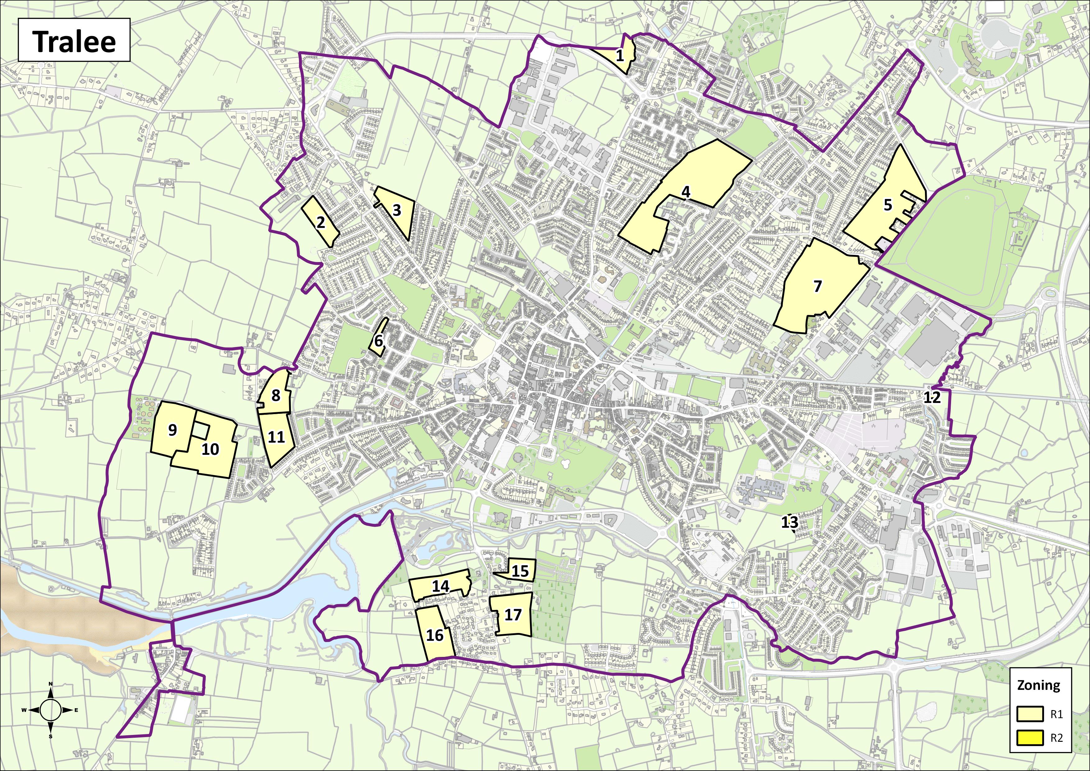
|
Tralee – Settlement Capacity Audit of Zoned Land |
||||||||||
|
ID |
Zoning |
Road Access |
Footpaths |
Public Lighting |
Foul/storm Sewer |
Water Supply |
Tier |
Area (ha) |
Estimated Density Units p/ha |
Potential Yield |
|
T-1 |
R1 |
✔ |
✔ |
✔ |
- |
✔ |
2 |
2.1 |
15-20 |
35-40 |
|
T-2 |
R1 |
✔ |
✔ |
✔ |
✔ |
✔ |
1 |
2.37 |
20-25 |
45-55 |
|
T-3 |
R1 |
✔ |
✔ |
✔ |
✔ |
✔ |
2 |
3.02 |
20-25 |
55-75 |
|
T-4 |
R1 |
✔ |
✔ |
✔ |
✔ |
✔ |
1 |
15.78 |
30-35 |
450-525 |
|
T-5 |
R1 |
✔ |
✔ |
✔ |
✔ |
✔ |
2 |
10.78 |
25-30 |
270-320 |
|
T-6 |
R1 |
✔ |
✔ |
✔ |
✔ |
✔ |
1 |
0.85 |
30-35 |
25-30 |
|
T-7 |
R1 |
✔ |
✔ |
✔ |
✔ |
✔ |
1 |
14.57 |
25-30 |
350-420 |
|
T-8 |
R1 |
✔ |
x |
x |
✔ |
v |
2 |
3.17 |
25-30 |
70-90 |
|
T-9 |
R1 |
✔ |
x |
x |
✔ |
✔ |
2 |
5.57 |
15-20 |
80-105 |
|
T-10 |
R1 |
✔ |
✔ |
✔ |
✔ |
✔ |
1 |
7.77 |
15-20 |
110-155 |
|
T-11 |
R1 |
✔ |
x |
x |
✔ |
✔ |
1 |
3.88 |
25-30 |
90-110 |
|
T-12 |
R1 |
✔ |
✔ |
✔ |
✔ |
✔ |
1 |
0.17 |
20-25 |
5-10 |
|
T-13 |
R1 |
✔ |
✔ |
✔ |
✔ |
✔ |
1 |
0.19 |
20-25 |
5 |
|
T-14 |
R1 |
✔ |
✔ |
✔ |
✔ |
✔ |
1 |
3.49 |
15-20 |
45-75 |
|
T-15 |
R1 |
✔ |
✔ |
✔ |
✔ |
✔ |
1 |
1.84 |
15-20 |
20-30 |
|
T-16 |
R1 |
✔ |
✔ |
✔ |
✔ |
✔ |
2 |
4.16 |
15-20 |
50-75 |
|
T-17 |
R1 |
✔ |
x |
✔ |
✔ |
✔ |
2 |
4.33 |
15-20 |
55-80 |
|
The potential yield from Phase 1 residential lands allows for the remainder of the housing target to be achieved on brownfield/infill sites. |
||||||||||
Killarney
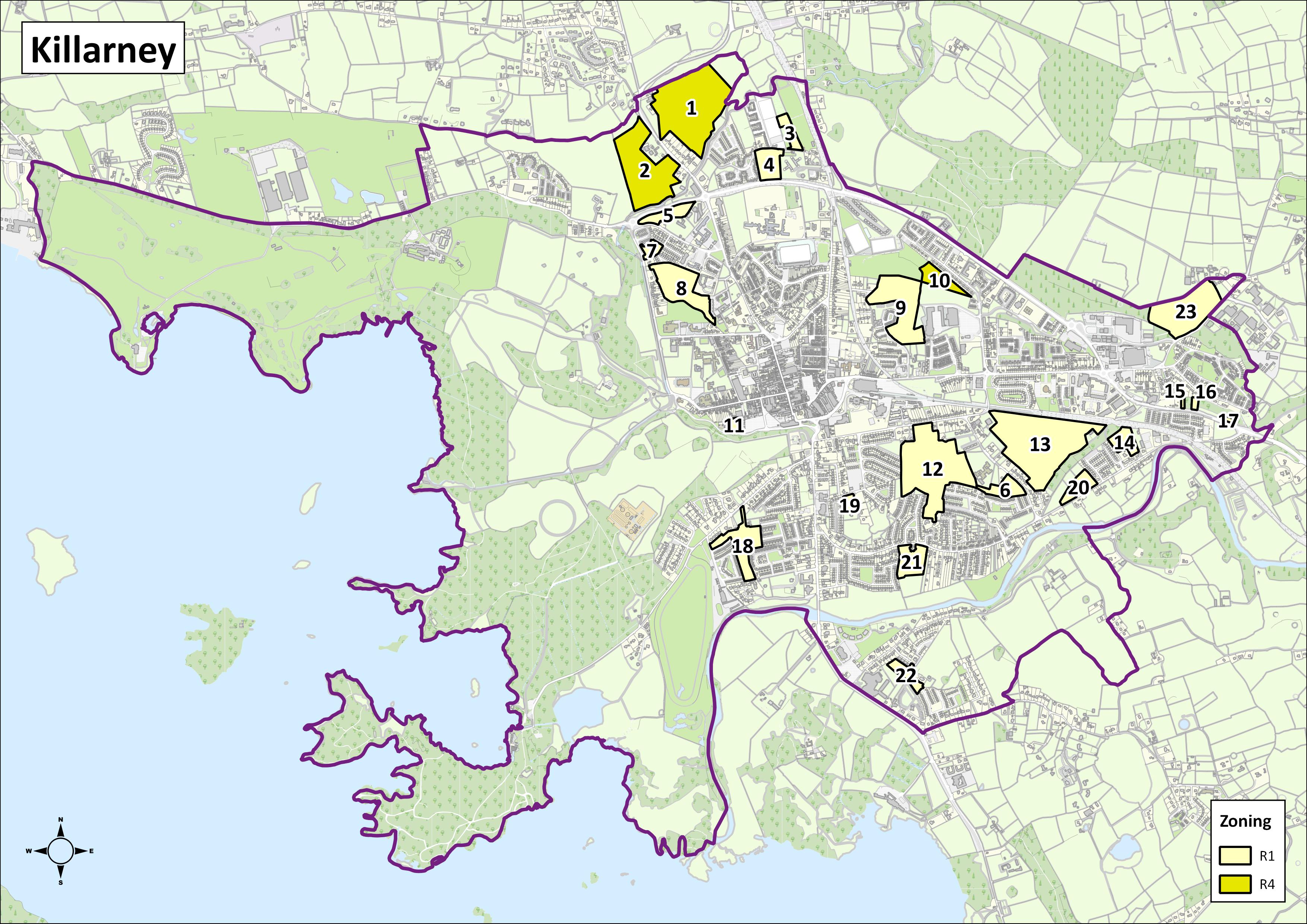
|
Killarney– Settlement Capacity Audit of Zoned Land |
||||||||||
|
ID |
Zoning |
Road Access |
Footpaths |
Public Lighting |
Foul/ Storm Sewer |
Water Supply |
Tier |
Area (ha) |
Estimated Density Units p/ha |
Potential yield |
|
K-1/2 |
R4 |
x |
✔ |
✔ |
✔ |
✔ |
2 |
24.07 |
- |
- |
|
K-3 |
R1 |
✔ |
x |
x |
✔ |
✔ |
2 |
1.19 |
20-25 |
15-25 |
|
K-4 |
R1 |
✔ |
x |
x |
✔ |
✔ |
2 |
2.35 |
20-25 |
40-55 |
|
K-5 |
R1 |
✔ |
✔ |
✔ |
✔ |
✔ |
1 |
1.69 |
25-30 |
35-50 |
|
K-6 |
R4 |
✔ |
✔ |
✔ |
✔ |
✔ |
2 |
1.81 |
25-30 |
40-55 |
|
K-7 |
R1 |
✔ |
✔ |
✔ |
✔ |
✔ |
1 |
0.79 |
25-30 |
15-25 |
|
K-8 |
R1 |
✔ |
✔ |
✔ |
✔ |
✔ |
1 |
4.12 |
30-35 |
155-200 |
|
K-9 |
R1 |
✔ |
✔ |
✔ |
✔ |
✔ |
1 |
7.1 |
25-30 |
170-200 |
|
K-10 |
R1 |
✔ |
✔ |
✔ |
✔ |
✔ |
1 |
1.94 |
- |
- |
|
K-11 |
R1 |
✔ |
x |
✔ |
✔ |
✔ |
1 |
0.45 |
35-40 |
10-20 |
|
K-12 |
R1 |
✔ |
✔ |
✔ |
✔ |
✔ |
2 |
13.03 |
25-30 |
300-370 |
|
K-13 |
R1 |
✔ |
✔ |
✔ |
✔ |
✔ |
2 |
15.15 |
25-20 |
350-430 |
|
K-14 |
R1 |
✔ |
✔ |
✔ |
✔ |
✔ |
1 |
1.66 |
20-25 |
25-40 |
|
K-15/16/17 |
R1 |
x |
✔ |
✔ |
x |
x |
2 |
0.58 |
- |
3 |
|
K-18 |
R1 |
✔ |
✔ |
✔ |
✔ |
✔ |
1 |
3.96 |
25-30 |
90-115 |
|
K-19 |
R1 |
✔ |
✔ |
✔ |
✔ |
✔ |
1 |
0.72 |
25-30 |
10-20 |
|
K-20 |
R1 |
✔ |
✔ |
✔ |
✔ |
✔ |
1 |
1.51 |
15-20 |
15-25 |
|
K-21 |
R1 |
✔ |
✔ |
✔ |
✔ |
✔ |
1 |
2.55 |
20-25 |
45-60 |
|
K-22 |
R1 |
✔ |
✔ |
✔ |
✔ |
✔ |
1 |
1.32 |
15-20 |
15-25 |
|
K-23 |
R1 |
✔ |
✔ |
✔ |
✔ |
✔ |
1 |
7.33 |
- |
94 |
|
The potential yield from Phase 1 residential lands allows for the remainder of the housing target to be achieved on brownfield/infill sites. |
||||||||||
Listowel
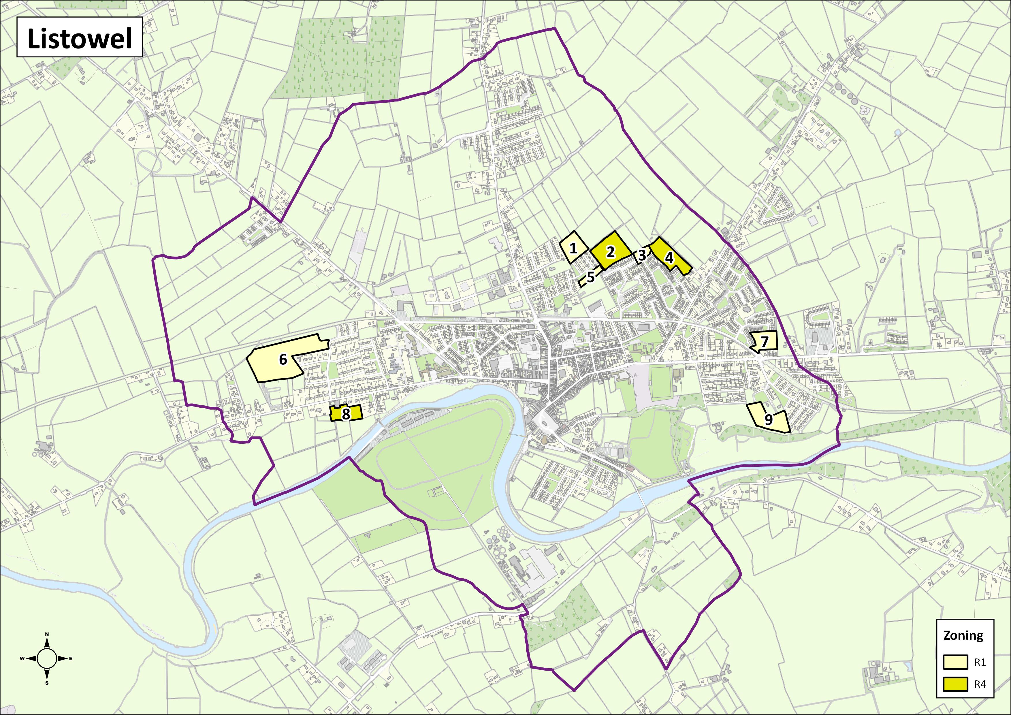
|
Listowel– Settlement Capacity Audit of Zoned Land |
|||||||||||
|
ID |
Zoning |
Road Access |
Footpaths |
Public Lighting |
Foul/ Storm Sewer |
Water Supply |
Tier |
Area (ha) |
Estimated Density Units p/ha |
Potential Yield |
|
|
L-1 |
R1 |
✔ |
✔ |
✔ |
✔ |
✔ |
1 |
1.32 |
30-35 |
40-50 |
|
|
L-2 |
R4 |
✔ |
✔ |
✔ |
✔ |
✔ |
2 |
2.2 |
- |
- |
|
|
L-3 |
R1 |
✔ |
✔ |
✔ |
✔ |
✔ |
1 |
0.45 |
25-30 |
10-20 |
|
|
L-4 |
R4 |
✔ |
✔ |
✔ |
✔ |
✔ |
2 |
1.79 |
- |
- |
|
|
L-5 |
R1 |
✔ |
✔ |
✔ |
✔ |
✔ |
1 |
0.45 |
20-25 |
10-20 |
|
|
L-6 |
R1 |
✔ |
✔ |
✔ |
✔ |
✔ |
1 |
5.53 |
15-20 |
85-120 |
|
|
L-7 |
R1 |
✔ |
✔ |
✔ |
✔ |
✔ |
1 |
1.17 |
25-30 |
25-40 |
|
|
L-8 |
R4 |
✔ |
✔ |
✔ |
✔ |
✔ |
2 |
1.14 |
- |
- |
|
|
L-9 |
R1 |
✔ |
✔ |
✔ |
✔ |
✔ |
1 |
1.85 |
15-20 |
25-40 |
|
|
The potential yield from residential lands allows for the remainder of the housing target to be achieved on brownfield/infill sites. |
|||||||||||
Contents
Observations
Observations