We welcome the prominence the plan affords (Chapter 2) to addressing the climate emergency, and we encourage KCC to more fully operationalise these principles throughout the plan. Paragraph 2.3.4...
6. Settlement Capacity Audit
Closed6 Dec, 2021, 00:01 - 23 Feb, 2022, 17:01
6. Settlement Capacity Audit
This is an analysis of the capacity of the key towns of Tralee and Killarney and the regional town of Listowel to accommodate new development in terms of suitable lands and infrastructure within the plan period. It confirms whether sites as zoned in their respective Town Plans are served by the necessary infrastructure so as to allow for their timely development. This ‘Settlement Capacity Audit’ (SCA) exercise accords with Appendix 3 (A Methodology for a Tiered Approach to Land Zoning) of the National Planning Framework, which distinguishes between lands that are Serviced (Tier 1) and those that Serviceable (Tier 2).
The SCA is an infrastructural assessment of lands within settlements and includes the following infrastructure categories:
- Road access
- Footpath access
- Foul & surface water sewerage drainage
- Water supply
The SCA exercise includes an examination of the capacity for new residential development within the built-up footprint of existing settlements in line with compact growth priorities of National Planning Policy 17.
The assessment identifies and maps zoned lands with residential development potential, including mixed use zoned lands. This includes the following:
- lands within the existing built up area;
- serviced greenfield ‘Tier 1’ tranches of land; and
- serviceable greenfield ‘Tier 2’ lands.
The lands zoned residential for Tralee, Killarney & Listowel are those as shown on the zoning maps included in Volume 2 and Volume 4.
Tralee
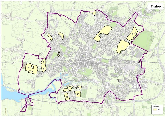
|
Tralee – Settlement Capacity Audit of Zoned Land |
||||||||
|
ID |
Zoning |
Road Access |
Footpaths |
Public Lighting |
Foul/storm Sewer |
Water Supply |
Tier |
Area (ha) |
|
T-1 |
R1 |
✔ |
✔ |
✔ |
- |
✔ |
2 |
2.1 |
|
T-2 |
R1 |
✔ |
✔ |
✔ |
✔ |
✔ |
1 |
2.37 |
|
T-3 |
R1 |
✔ |
✔ |
✔ |
✔ |
✔ |
2 |
3.02 |
|
T-4 |
R1 |
✔ |
✔ |
✔ |
✔ |
✔ |
1 |
15.78 |
|
T-5 |
R1 |
✔ |
✔ |
✔ |
✔ |
✔ |
1 |
10.79 |
|
T-6 |
R1 |
✔ |
✔ |
✔ |
✔ |
✔ |
1 |
0.85 |
|
T-7 |
R1 |
✔ |
✔ |
✔ |
✔ |
✔ |
1 |
14.57 |
|
T-8 |
R1 |
✔ |
x |
x |
✔ |
✔ |
1 |
3.1 |
|
T-9 |
R1 |
✔ |
x |
x |
✔ |
✔ |
2 |
5.5 |
|
T-10 |
R1 |
✔ |
✔ |
✔ |
✔ |
✔ |
1 |
8.4 |
|
T-11 |
R1 |
✔ |
x |
x |
✔ |
✔ |
2 |
3.8 |
|
T-12 |
R1 |
✔ |
✔ |
✔ |
✔ |
✔ |
1 |
0.17 |
|
T-13 |
R1 |
✔ |
✔ |
✔ |
✔ |
✔ |
1 |
0.19 |
|
T-14 |
R1 |
✔ |
✔ |
✔ |
✔ |
✔ |
1 |
3.48 |
|
T-15 |
R1 |
✔ |
✔ |
✔ |
✔ |
✔ |
1 |
1.84 |
|
T-16 |
R1 |
✔ |
✔ |
✔ |
✔ |
✔ |
2 |
4.16 |
|
T-17 |
R1 |
✔ |
x |
✔ |
✔ |
✔ |
2 |
4.33 |
Killarney
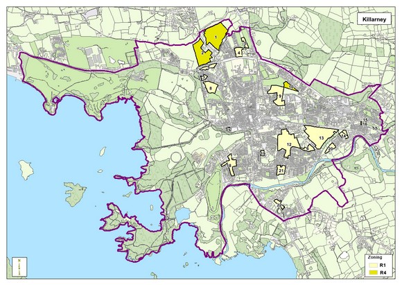
|
Killarney – Settlement Capacity Audit of Zoned Land |
||||||||
|
ID |
Zoning |
Road Access |
Footpaths |
Public Lighting |
Foul/ storm Sewer |
Water Supply |
Tier |
Area (ha) |
|
K-1 |
R4 |
x |
✔ |
✔ |
✔ |
✔ |
2 |
14.12 |
|
K-2 |
R4 |
x |
x |
x |
✔ |
✔ |
2 |
9.95 |
|
K-3 |
R4 |
✔ |
x |
x |
✔ |
✔ |
2 |
1.19 |
|
K-4 |
R4 |
✔ |
x |
x |
✔ |
✔ |
2 |
2.35 |
|
K-5 |
R1 |
✔ |
✔ |
✔ |
✔ |
✔ |
1 |
1.69 |
|
K-6 |
R4 |
✔ |
✔ |
✔ |
✔ |
✔ |
1 |
2 |
|
K-7 |
R1 |
✔ |
✔ |
✔ |
✔ |
✔ |
1 |
0.79 |
|
K-8 |
R1 |
✔ |
✔ |
✔ |
✔ |
✔ |
1 |
5.37 |
|
K-9 |
R1 |
✔ |
✔ |
✔ |
✔ |
✔ |
1 |
7.1 |
|
K-10 |
R4 |
✔ |
✔ |
✔ |
✔ |
✔ |
1 |
1.93 |
|
K-11 |
R1 |
✔ |
x |
✔ |
✔ |
✔ |
1 |
0.45 |
|
K-12 |
R1 |
✔ |
✔ |
✔ |
✔ |
✔ |
1 |
14.84 |
|
K-13 |
R1 |
✔ |
✔ |
✔ |
✔ |
✔ |
1 |
15.31 |
|
K-14 |
R1 |
✔ |
✔ |
✔ |
✔ |
✔ |
1 |
1.66 |
|
K-15 |
R4 |
x |
✔ |
✔ |
x |
x |
2 |
0.12 |
|
K-16 |
R4 |
x |
✔ |
✔ |
x |
x |
2 |
0.25 |
|
K-17 |
R4 |
x |
✔ |
✔ |
x |
x |
2 |
0.21 |
|
K-18 |
R1 |
✔ |
✔ |
✔ |
✔ |
✔ |
1 |
4.3 |
|
K-19 |
R1 |
✔ |
✔ |
✔ |
✔ |
✔ |
1 |
0.72 |
|
K-20 |
R1 |
✔ |
✔ |
✔ |
✔ |
✔ |
1 |
1.51 |
|
K-21 |
R1 |
✔ |
✔ |
✔ |
✔ |
✔ |
1 |
2.55 |
|
K-22 |
R1 |
✔ |
✔ |
✔ |
✔ |
✔ |
1 |
1.32 |
Listowel
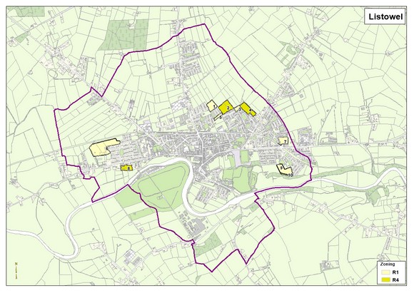
|
Listowel – Settlement Capacity Audit of Zoned Land |
||||||||
|
ID |
Zoning |
Road Access |
Footpaths |
Public Lighting |
Foul/ storm Sewer |
Water Supply |
Tier |
Area (ha) |
|
L-1 |
R4 |
✔ |
✔ |
✔ |
✔ |
✔ |
2 |
2.2 |
|
L-2 |
R1 |
✔ |
✔ |
✔ |
✔ |
✔ |
1 |
1.32 |
|
L-3 |
R1 |
✔ |
✔ |
✔ |
✔ |
✔ |
1 |
0.45 |
|
L-4 |
R4 |
✔ |
✔ |
✔ |
✔ |
✔ |
2 |
1.79 |
|
L-5 |
R1 |
✔ |
✔ |
✔ |
✔ |
✔ |
1 |
0.45 |
|
L-6 |
R1 |
✔ |
✔ |
✔ |
✔ |
✔ |
1 |
5.53 |
|
L-7 |
R1 |
✔ |
✔ |
✔ |
✔ |
✔ |
1 |
1.17 |
|
L-8 |
R4 |
✔ |
✔ |
✔ |
✔ |
✔ |
2 |
1.14 |
|
L-9 |
R1 |
✔ |
✔ |
✔ |
✔ |
✔ |
1 |
1.85 |
Contents
Observations
Observations