please see attcahed for suggested amanedmants to additions/amendments to policies and objectives
Chapter 11: Environment
Closed6 Dec, 2021, 00:01 - 23 Feb, 2022, 17:01
Contents
11.3 Air, Noise and Light Pollution
11.5 Land Use & Flood Risk Management
______________________________________________
11.0 Environment
11.1 Introduction
This Chapter contains the general planning policies and principles which will ensure that the natural environment, biodiversity and ecosystems are protected, delivering benefits essential for all sectors of society and that it contributes to efforts to reverse the loss of biodiversity and the degradation of ecosystems and the environment. This Chapter is complimented by Chapter 13 Water and Waste Management.
Environmental protection is a core component of the RSES, County Development Plan and the Core Strategy which underlines the need to safeguard and enhance our environment through sustainable development, transitioning to a carbon neutral, biodiversity rich and climate resilient society and environmentally sustainable economy by 2050.
County Kerry’s natural environment includes a wealth of features that encompass the character of the County. Kerry’s diverse landscapes form part of its ‘green’ persona and there is much to be proud of. These features are influenced by its geographical location, its climatic conditions, the changing global impact on environmental and climatic conditions as well as the impact of human behaviour at local level.
The county’s natural environment encompasses; its unique world renowned landscape, including the country’s highest mountain ranges, Killarney & Derrynane national parks, salmonoid rivers, dramatic coastal formations incorporating sheer cliff faces to extensive sandy beaches, its renowned islands including the UNESCO world heritage site of Sceilig Mhichil and the Great Blasket Islands, its significant peninsulas from the Kenmare River in the South to the Mouth of the Shannon in the North; its ecological diversity from the protected landscapes of the Kenmare Region to the harsh exposure of West Kerry and upland areas, the Kerry UNESCO Biosphere incorporating Killarney National Park and the Macgillicuddy Reeks, the rich pastures of North Kerry and the upland moorland areas; its wildlife, including the Killarney Native Deer, natterjack toad and pearl mussels. This natural environment is framed by and constantly changed by the influence of the temperate climate of high rainfall and prevailing south westerly winds and the impact of the Atlantic Ocean.
In addition to having its own intrinsic value, the natural environment provides opportunities for sustainable recreational activities, employment and tourism and provides natural resources such as drinking water and raw materials which can facilitate sustainable development. It is necessary for these features to be protected to the standards required by national legislation and European Directives, whilst accommodating sustainable development in appropriate locations to facilitate sustainable economic growth and development.
The conservation of biodiversity is also of particular significance in Kerry given its rich natural heritage of wildlife habitats, species, geological features and landforms, including some of international importance.
11.2 Biodiversity
In recent years “biodiversity” has come to replace more familiar words such as “wildlife”, “natural heritage” or “nature”. Simply defined as “all life on Earth” biodiversity plays a key role in how “nature” all around us functions providing us with many services. Called “ecosystem services” they include providing clean air, water, food, fuel, medicines, recreation, and protection from extreme weather. Biodiversity also supports pollination; soil fertility and regulates our climate. It underpins and supports many of our economic activities particularly food production. However, biodiversity also underpins our health and well-being. COVID-19 and the associated restrictions has shown many the value of the natural environment for our physical health and mental wellbeing.
In short, biodiversity is crucial to our lives. It underpins and supports nearly all our activities. Alarmingly, many international reports continue to report an unprecedented decline in global biodiversity. This is reflected in the EPA’s most recently published 2020 State of the Environment Report. Similarly, the EPA’s published reports on the Status of Water Quality in Ireland, 2013-2018 (published in 2019) indicates some worrying national trends on the ecological health and water quality of Ireland’s rivers, lakes, estuaries, groundwater, and coastal waters. Coupled with these alarming trends in the natural world is the unprecedented challenges faced by climate change. Ireland, or indeed Kerry, is not immune to these global trends.
Kerry has a diverse and varied biodiversity. Over 40% of the county is designated under the Natura 2000 network highlighting the significance of the county’s natural heritage at a European level. The primary threats to biodiversity both within and outside designated areas are from habitat loss, degradation and/or fragmentation. As a land use plan, the CDP has an important role to play in guiding sustainable development patterns thereby ensuring the protection and sustainable management of our biodiversity including natural resources. Biodiversity as a means to both mitigate and adapt to climate change has also recently gained momentum. In particular, it offers possible nature-based solutions to many of the climate challenges facing us. A multi-beneficiary or co-benefits approach to the conservation of biodiversity is supported in this CDP. Objectives/policies are included that seek to protect the county’s biodiversity, augment its ability to offer positive/multi-beneficiary/co-benefit responses to climate change and reverse declining trends.
11.2.1 European/National Designations
Biodiversity protection is afforded by International, European and National legislation, most particularly the EU Habitats and Birds Directives, the Planning and Development (Amendment) Act, 2001 (as amended), the EU (Natural Habitats) Regulations 2011 and the Irish Wildlife Acts (1976 and 2000).
Natura 2000 sites (also referred to as European Sites, the terms are used interchangeably in this plan), are a pan-EU wide network of nature protection areas known as Special Protection Areas (SPAs) and Special Areas of Conservation (SACs). They are the centrepiece of EU nature & biodiversity policy and are derived from the Habitats and Birds Directives. The aim of the Natura 2000 network is to assure the long-term survival of Europe’s most valuable and threatened species and habitats. This plan seeks to protect and manage the Natura 2000 Network in the County. The Planning Authority will assess all plans and projects for compliance with Article 6 of the Habitats Directive in accordance with the DEHLG (2010) Appropriate Assessment of Plans and Projects in Ireland.
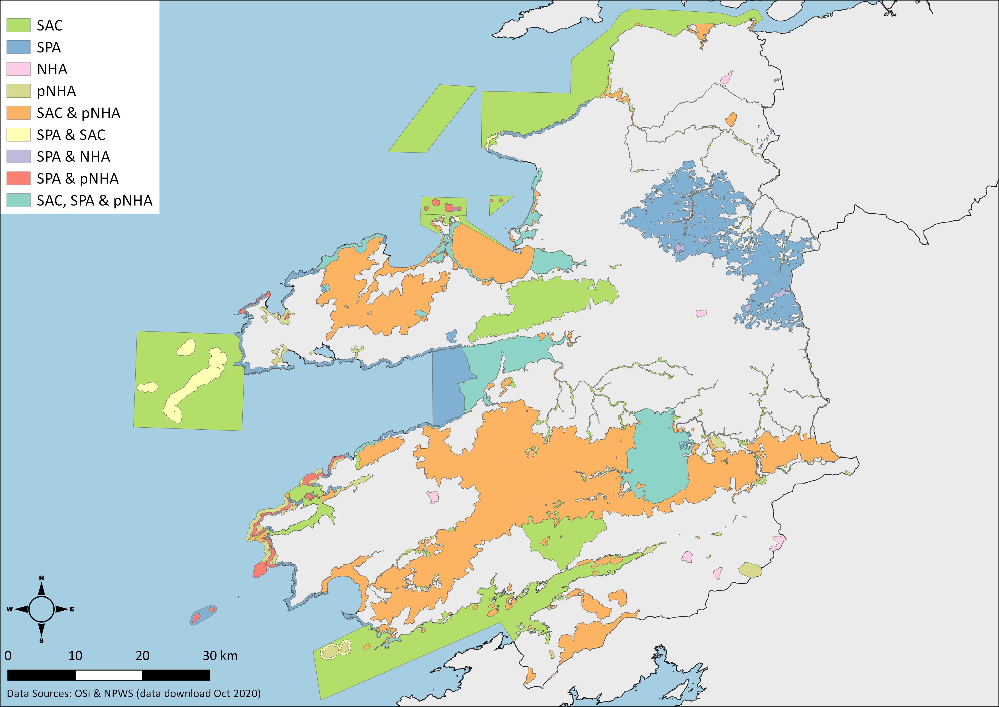
Map 11.1: Designated Sites (SAC/SPA/NHA/pNHA) (click to enlarge)
Exempted development is de-exempted (i.e., the development requires planning permission) where such works/development require an Appropriate Assessment. A Section 5 declaration may be sought from the Council as to whether any proposed work (i) is or is not development and (ii) is or is not exempted development.
Nationally designated conservation areas include Natural Heritage Areas (NHAs) and proposed Natural Heritage Areas (pNHAs). NHAs are a national designation introduced by the Wildlife (Amendment) Act 2000. In Kerry there are 9 NHAs all designated for peatland habitats. pNHAs are sites which have not progressed to NHA status but nonetheless are likely to have ecological or geological value. There are 61 pNHAs in Kerry (many overlapping with Natura 2000 sites) protected by the provisions of the CDP.
A list of all nature conservation designations within the county is provided in Volume 1: Appendices and shown in Map 11.1.
|
Biodiversity |
|
|
It is an objective of the Council to: |
|
|
KCDP 11-1 |
Ensure that the requirements of relevant EU and national legislation, are complied with by the Council in undertaking its functions, including the requirements of the EU Birds and Habitats Directives. |
|
KCDP 11-2 |
Maintain the nature conservation value and integrity of Natural Heritage Areas (NHAs) and proposed Natural Heritage Areas (pNHAs). This shall include any other sites that may be designated at national level during the lifetime of the plan in co-operation with relevant state agencies. |
|
KCDP 11-3 |
Work with all stakeholders in order to conserve, manage and where possible enhance the County’s natural heritage including all habitats, species, landscapes and geological heritage of conservation interest and to promote increased understanding and awareness of the natural heritage of the County. |
|
KCDP 11-4 |
Promote nature-based solutions to meet national objectives towards achieving a carbon neutral economy by 2050. |
|
KCDP 11-5 |
Support and facilitate the actions in the National Biodiversity Action Plan and Kerry County Councils Biodiversity Action Plan 2022 – 2028. |
|
KCDP 11-6 |
Support community groups undertaking biodiversity projects and any opportunities that may arise from biodiversity funding/grants. |
|
KCDP 11-7 |
Support community groups undertaking biodiversity projects and any opportunities that may arise from biodiversity funding/grants. |
|
KCDP 11-8 |
Support the recording of biodiversity data in the county and its referral to National Biodiversity Data Centre. |
|
KCDP 11-9 |
Support Agri-environment schemes; the MacGillycuddy Reeks Mountain Access Reeks Forum, the Magharees Conservation Association; EIPs; EU LIFE projects and other existing or proposed biodiversity programmes being undertaken in the county. |
11.2.2 Killarney National Park and Kerry UNESCO Biosphere Reserve
Killarney National Park contains many features of national and international importance such as native oakwoods and yew woods together with an abundance of evergreen trees, shrubs, rare bryophytes and lichens which thrive in the mild Killarney climate.
The former Killarney National Park Biosphere Reserve managed by the National Parks and Wildlife Service (NPWS) has been redesigned, re-named and extended according to UNESCO Biosphere Reserve criteria. The Kerry Biosphere now includes Killarney National Park as its core, with the Macgillycuddy Reeks and other parts of the Special Area of Conservation (SAC) to the south and east of the National Park as a buffer, and with Killarney town and the Lough Leane catchment as a transition zone. Outside of the National Park Kerry County Council is an active partner with NPWS in the management of the buffer and transition zones of the biosphere reserve in support of NPWS.
|
Killarney National Park and Kerry UNESCO Biosphere Reserve It is an objective of the Council to: |
|
|
KCDP 11-10 |
Support the NPWS in the ongoing management of Killarney National Park. |
|
KCDP 11-11 |
Work with NPWS and other partners to support the Kerry UNESCO Biosphere Reserve and the implementation of initiatives contained in the Periodic Review 2017. |
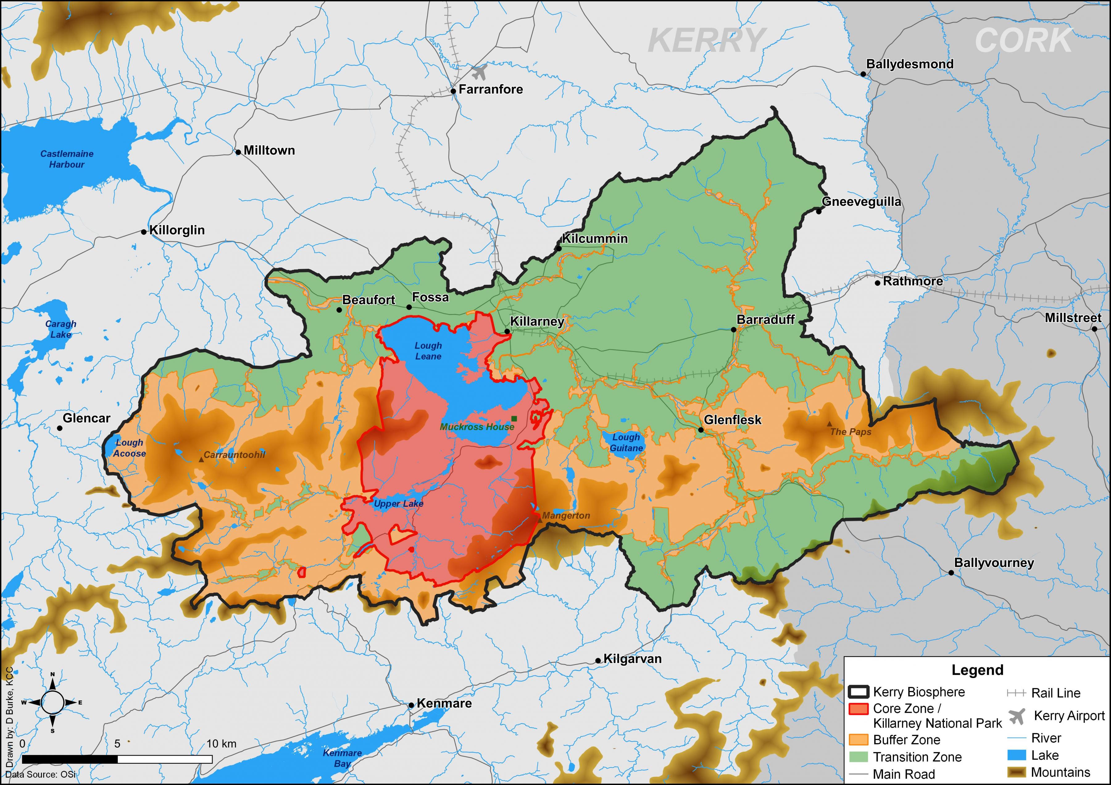
Map 11.2: Kerry Biosphere Reserve (click to enlarge)
11.2.3 Wetlands
Wetlands have a valuable and beneficial role in flood regulation, water purification, wildlife habitat, and recreation. Wetlands include a wide range of habitats including swamps, marshes, peatlands, wet heath and inter-tidal areas. Several ecologically diverse peatlands are designed in the county including a number within SACs and NHAs. Wetlands, in particular peatlands, can be important carbon sinks and can contain archaeological features of interest. A number of wetlands in the County offer educational, recreational and micro business opportunities, most notably the Tralee Bay Wetlands Centre.
Two Ramsar Sites, an international designation for wetland sites that support significant populations of wintering waterfowl, occur in the county. These sites which are located in Castlemaine Harbour and Tralee Bay, overlap with SPA designations.
Proposals for the drainage/reclamation of wetlands are governed by provisions of the Planning and Development Regulations, 2001 (as amended). This includes the relevant provisions relating to the Environmental Impact Assessment Directive. This plan supports the protection of wetlands as defined in the regulations and in the Draft Guidance for Planning Authorities on Drainage and Reclamation of Wetlands, Department of Environment, Community and Local Government, 2011 (or future versions).
|
Wetlands It is an objective of the Council to: |
|
|
KCDP 11-12 |
Support the sustainable use of wetlands, including our Ramsar sites, for educational, recreational and or tourism uses where appropriate and compatible with environmental protection designations. |
|
KCDP 11-13 |
Support actions identified in Ag Climitise including on-farm measures to sequester carbon by the establishment of wetlands at appropriate locations. |
11.2.4 Invasive Species
Invasive plant and animal species are often cited as the second greatest threat to biodiversity worldwide after habitat destruction. They can negatively impact on native species, can transform habitats and threaten whole ecosystems causing serious problems to the environment, agriculture and the economy. Introduced invasive species tend to reproduce rapidly and are difficult to eradicate once established. Roadsides and brown field/ derelict lands are of particular risk due to their accessibility and to the high concentrations of disturbed soil generally found at these locations. It is therefore very important to prevent the movement of earth contaminated with propagule material (e.g., seeds, rhizomes / roots, cuttings from hedge trimming or other fragments) from one area to another.
|
Invasive Species It is an objective of the Council to: |
|
|
KCDP 11-14 |
Ensure invasive species are managed in compliance with the provisions of the EC (Birds and Habitats) Regulations (SI 477 of 2011), as amended, particularly Sections 49, 50 and the Third Schedule. Best practices, as produced and updated by relevant authorities, are to be adhered to in the management of invasive species particularly on sites proposed for development. |
|
KCDP 11-15 |
Facilitate, in collaboration with relevant stakeholders increased awareness and the implementation of biosecurity measures to prevent the spread of invasive species, particularly along watercourses. |
|
KCDP 11-16 |
Facilitate the provision of an appropriate site in the County for the disposal and managment of invasive species and contaminated soil, further to best practice guidelines and the provisions of the EC (Birds and Habitats) Regulations (SI 477 of 2011), as amended. |
11.2.5 All-Ireland Pollinator Plan 2021-2025
The All-Ireland Pollinator Plan 2021-2025 sets out natural management measures to increase habitats and food for wild pollinators. Actions include a change in the management of grasslands, reduction in the use of pesticides, management of hedgerow cutting and the retention of unmanaged roads and park areas. The council supports the implementation of the All-Ireland Pollinator Plan 2021-2025 (and any replacement plans) and will have regard to the actions of this Plan when managing parks, open spaces, and roadside verges.
|
All-Ireland Pollinator Plan 2021-2025 It is an objective of the Council to: |
|
|
KCDP 11-17 |
Support actions from the All-Ireland Pollinator Plan including the plan’s recommendations for grassland management and pollinator friendly species. |
11.2.6 Green and Blue Infrastructure - Ecological/Urban Blue Corridors
Ecological corridors/ steppingstones are habitat patches that may not necessarily be of high conservation value themselves but serve to maintain ecological connectivity in the landscape. An ecological corridor permits the movement of wildlife between areas of high conservation interest or through areas that have little ability to support these species. Examples of ecological corridors include field boundaries comprising of stone walls, hedgerows and treelines, which support biodiversity by providing food and shelter for plants and animals. These may form part of green infrastructure proposals. Ecological corridors can also be classed as blue infrastructure essentially watercourses. They also act as pathways along which species travel and disperse though the wider countryside. Urban Blue Corridors can provide many co-benefits including more effective management of urban flood risk, improved access, additional and more useable public open space, and improved biodiversity. Given the extent of the Tarbert Ballylongford landbank and its location relative to areas of nature conservation value, it is of particular importance that ecological connectivity at a landscape level is taken into account as part of development proposals for this area.
A primary threat to biodiversity both within and outside protected areas is habitat degradation, fragmentation and loss of these ecological corridors. The cumulative impact of loss of ecological corridor features on an incremental or site-by-site basis over time can have significant repercussions for biodiversity in the County, including both designated and non-designated habitats and species. To address this issue, Kerry County Council will, where it is considered necessary, require planning applications to be accompanied by habitat mapping of the proposed development site. Habitat mapping can also be useful at a strategic level in identifying landscape features of ecological value. In recent years, habitat maps have been prepared for the towns of Tralee, Killarney, Listowel, Cahersiveen and Tarbert. The CDP supports the ongoing mapping of habitats at a strategic level to inform future land use planning in the County and Municipal Districts.
|
Green and Blue Infrastructure – Ecological/Urban Blue Corridors It is an objective of the Council to: |
|
|
KCDP 11-18 |
Require, where necessary, proposals to be accompanied by a habitat map prepared in accordance with the Heritage Councils Best Practice Guidance for Habitat Survey and Mapping, 2011. |
|
KCDP 11-19 |
Encourage and facilitate the retention and creation of features of local biodiversity value, ecological corridors and networks that connect areas of high conservation value such as watercourses, woodlands, hedgerows, earth banks and wetlands. |
|
KCDP 11-20 |
Identify key areas in the County, in collaboration with other relevant bodies, where habitat mapping would be of particular benefit to record existing features of local biodiversity and where applicable to integrate this information in the development management and plan preparation process. |
|
KCDP 11-21 |
Promote the integration and improvement of natural watercourses in development proposals having regard to the IFI’s guidance Planning for Watercourses in the Urban Environment. |
11.2.7 Urban Ecology
Urban habitats are sometimes viewed as being less important than rural habitats, however urban settlements are often located near biodiversity hotspots, such as along rivers or on the coast. In urban areas, artificial habitats such as parks and water features also support wildlife, and this can be enhanced through improved wildlife friendly management. Studies have also found brownfield sites, in certain instances to be diverse for flora, particularly those that persist longer on nutrient poor substrate or under disturbance. Private gardens can also encourage wildlife and buildings can incorporate biodiversity through features such as green roofs and living walls. These features can play an important role in supporting biodiversity in urban areas.
|
Urban Ecology It is an objective of the Council to: |
|
|
KCDP 11-22 |
Support projects such as the swift nesting project (that are compatible with protection of our architectural heritage); pollinator friendly initiatives, tree planting, nature based sustainable urban drainage systems and other actions that seek to enhance urban wildlife. |
11.2.8 Woodlands and Trees
Trees and woodlands, particularly those that are broadleaf deciduous, provide a valuable resource in terms of both biodiversity and by contributing to a varied, interesting, and attractive landscape. Kerry County Council will seek to protect trees, groups of trees and woodland areas of particular importance due to their biodiversity or visual amenity value. Careful consideration will be given to the potential impact of proposed developments on trees. Landowners and developers will be encouraged to retain existing trees and hedgerows, where practicable and to plant additional trees of native species, locally provenanced and grown where possible. Local provenance refers to the use of plantings derived from local seed or other propagule material. Plants sourced from outside of the Country can bring diseases which can threaten native stocks (e.g., Ash die back). Where the Council is satisfied that existing trees cannot be retained, for example due to poor condition or location within the site it will require acceptable replacement planting using native species. The Council will also have regard to the Tree Preservation Guidelines in this matter.
The Tralee MD Tree Management Strategy 2020-2025 sets out the Tralee MD’s approach to managing trees in its care in urban centres so as to maximise their long-term benefit within the built environment. Tree management strategies are to be undertaken for all Municipal District areas in the county.
|
Woodlands and Trees It is an objective of the Council to: |
|
|
KCDP 11-23 |
Facilitate and support the actions of the tree management strategy for the respective municipal districts. |
|
KCDP 11-24 |
Support the preservation and enhancement of the general level of broadleaf tree cover throughout the County in both urban and rural areas and ensure that development proposals satisfactorily retain existing trees and/or provide additional native planting. A Tree Survey Report shall inform applications where appropriate. |
|
KCDP 11-25 |
Encourage the provision of locally provenanced native tree species including those recommended by the All-Ireland Pollinator Plan as part of development landscaping schemes. |
|
KCDP 11-26 |
Work with stakeholders to protect and sustainably enhance the biodiversity and where appropriate the landscape and recreational interests of woodlands in the County. |
11.3 Air, Noise and Light Pollution
The creation of a cleaner environment is essential for a healthy and vibrant community. The improvement of air and noise quality is paramount to prevent people being exposed to unacceptable levels of pollution that can impact on their health and/or well-being.
11.3.1 Air Pollution
The latest EPA Air Quality in Ireland Report 2019 reports that particulate matter from the burning of solid fuels, including wood, coal and peat, poses the greatest threat to human health with the problem most acute in small towns and rural areas. The second biggest cause of pollutants is nitrogen dioxide from cars, particularly heavily trafficked urban areas. The protection of air quality requires cross-sectoral policy responses to address air pollution emissions from transport (diesel) energy (peat, biomass) and home heating (solid fuel). Tralee and Killarney are included as “Low Smoke Zones” under the Smoky Coal Ban Regulations 2012-2020.
The Council will continue to seek to improve air quality by having regard to National Emissions Ceiling Directive (NECD) and the Air Quality Standards Regulations 2011 (S.I. No. 180 of 2011) which implements Directive 2008/50/EC on ambient air quality and cleaner air for Europe. The Council will also encourage the use of the best available technology (BAT) in specific industrial facilities likely to give rise to emissions concerns, including air and odour.
The policies and objectives of this plan also take inspiration from and are consistent with the Climate Action Plan 2019 and the NPF. In particular, this plan integrates land use and planning, prioritises the development of infill and brownfield sites, priorities walking, cycling and public transport over the private car and encourages energy efficient buildings and green infrastructure. This will make a significant contribution over the lifetime of this plan to reducing atmospheric particulate matter, nitrogen dioxide and GHG emissions thereby greatly improving air quality.
11.3.2 Noise Pollution
Noise pollution can occur in various locations including building sites, heavily trafficked roads, industrial sites, all of which can have significant impacts on an environment and on the quality of life of individuals, residential amenities and communities in an area.
The EPA Act, 1992 identifies noise as a form of environmental pollution and contains provisions for dealing with noise “which is a nuisance or would endanger human health or damage property or harm the environment”. The WHO recognises the growing understanding of health impacts from exposure to environmental noise as outlined in their 2018 Environmental Noise Guidelines for the European Region.
Existing noise legislation in Ireland provides for the strategic control of environmental noise from major infrastructure and industry. Legislation also provides for control of noise at specific sources and the method in which this can be undertaken. The Environmental Noise Directive (2002/49/EC) aims to put in place a European wide system for identifying sources of environmental noise, informing the public about relevant noise data and taking the necessary steps to avoid, prevent or reduce noise exposure. The Directive was transposed in Ireland by SI 549 of 2018 European Communities (Environmental Noise) Regulations 2018. Under these regulations a Noise Action Plan (2019) has been prepared by TII and KCC to address environmental noise from major national roads in the county.
The EPA’s IPC Licensing terms require that certain bodies must limit environmental pollution caused by industrial activities in order to obtain a license to operate. The criteria relating to noise pollution are outlined in the EPA publication “Guidance Note for Noise: Licence Applications, Surveys and Assessment in Relation to Scheduled Activities (NG4)”, published in January 2016. This document recommends a “Best Available Technique” approach to the assessment and mitigation of noise pollution. The document contains typical limit values for daytime (55dB LAr,T), evening (50dB LAr,T) and night time (45dB LAr,T) noise, at sensitive locations, from licensed facilities.
In line with NPO 65 of the NPF, the Council will promote the pro-active management of noise where it is likely to have significant adverse impacts on health and quality of life and will continue to manage environmental noise through land-use planning, traffic management and control of noise sources. This is to ensure that all future developments are designed and constructed to minimise noise disturbance.
|
Air and Noise Pollution It is an objective of the Council to: |
|
|
KCDP 11-27 |
Improve and maintain good air quality and support measures to prevent harmful effects on human health and the environment in our urban and rural areas. |
|
KCDP 11-28 |
Promote the development of energy efficient buildings and homes, heating systems with zero local emissions, green infrastructure planning and innovative design solutions and promotion of measures that improve air quality including provision and management of green infrastructure. |
|
KCDP 11-29 |
Promote a modal change from private car use to other types of travel and to promote the use of public transport as a means of reducing greenhouse gas emissions and improving air quality. |
|
KCDP 11-30 |
Carry out traffic management measures such as reduction of speed limits, traffic flow control, mitigation of environmental noise hotspots, traffic congestion management, road surface improvements and road maintenance and the promotion of the use of electric vehicles. |
|
KCDP 11-31 |
Support measures, as they evolve nationally, from the Climate Action Plan 2019 and subsequent plans to introduce low- and zero-emission driving zones. |
|
KCDP 11-32 |
Ensure that any application with the potential to create noise nuisance is appropriately assessed and that suitable measures to mitigate any nuisance are proposed and implemented. |
|
KCDP 11-33 |
Support the KCC’s 2019 Noise Action Plan, Round 3 and future iterations over the lifetime of this plan |
|
KCDP 11-34 |
Incorporate the aims of the present and future Noise Action Plans into relevant local area plans, protecting larger areas from road noise. Special consideration will be given to zoning objectives, speed limits and established settlements within the area. |
|
KCDP 11-35 |
Undertake a strategic approach, where deemed appropriate, to manage environmental noise in order to prevent members of the community being exposed to high noise levels in new developments. |
|
KCDP 11-36 |
Assess all planning applications with respect to noise and their potential impact on noise sensitive receptors in accordance with the WHO and EPA Guidelines ‘Environmental Noise Guidelines for the European Region’ 2018, and the UK publication ‘ProPG: Planning & Noise, Professional Practice Guidance on Planning & Noise New Residential Development, May 2017’. |
|
KCDP 11-37 |
Ensure all new road infrastructure projects will be assessed in accordance with Transport Infrastructure Ireland (TII) Guidance and mitigation measures provided where deemed appropriate. |
11.3.3 Light Pollution
When used inappropriately or excessively, artificial lighting can cause light pollution. This has adverse effects on the environment, our health, biodiversity, and our climate (through energy waste).
There are four components of light pollution:
- Glare - excessive brightness that causes visual discomfort.
- Skyglow - brightening of the night sky over inhabited areas.
- Light trespass - light falling where it is not intended or needed.
- Clutter - bright, confusing and excessive groupings of light sources.
11.3.3.1 Kerry International Dark-Sky Reserve
International Dark Sky Reserves (www.darksky.org) are areas recognised as possessing an exceptional or distinguished quality of starry nights and nocturnal environment specifically protected for scientific, natural, educational, cultural, heritage or public enjoyment. The Kerry International Dark-Sky Reserve measures approximately 700 km² and includes Kells/Folimore, Cahersiveen, Portmagee, Valentia Island, Dromid, The Glen, Ballinskelligs, Waterville and Derrynane/Caherdaniel.
The plan recognises the potential of the Dark-Sky reserve as a significant tourism attraction, and as a result the control of light pollution in this area is important. This is particularly true of mountainous and peatland areas where there is little or no light pollution, serviced by adjoining rural communities.
It is an objective of this plan and where resources allow to replace the public lighting system throughout Kerry with a more energy efficient, money saving, dark-sky compliant lighting system. The council will also encourage measures to support the Kerry International Dark-Sky Reserve throughout the lifetime of the Plan.
|
Light Pollution It is an objective of the Council to: |
|
|
KCDP 11-38 |
Require proposals for development that include the provision of external lighting, to clearly demonstrate that the lighting scheme is the minimum needed for security and working purposes and also to ensure that external lighting and lighting schemes are designed so that the incidence of light spillage is minimised ensuring that the amenities of adjoining properties, wildlife and the surrounding environment are protected. |
|
KCDP 11-39 |
Support the Kerry International Dark-Sky Reserve and ensure that all new external lights comply with the objectives of the Kerry International Dark Sky Reserve. |
11.3.3.2 Lights and Biodiversity
Excessive or directional lighting can also impact on nocturnal species effecting their ability to forage (feed) or commute. Bat species vary in their sensitivity to light pollution. Kerry has international important populations of the annexed II Lesser Horseshoe bat, a bat species particularly vulnerable to light pollution and habitat loss and fragmentation arising from same.
|
Lights and Biodiversity It is an objective of the Council to: |
|
|
KCDP 11-40 |
Take into consideration the Bat Conservation Trust 2018 Note 08/18 Bats and Artificial Lighting in the UK Guidelines when choosing lighting specifications for developments and/or Bat specialist advice, so as to ensure the requirements of the Habitats Directive are adhered to, including Article 10. |
11.4 Marine
Kerry has 684km of coastline which is a significant resource in terms of visual amenity, recreation, tourism, biodiversity, ports/harbours, fishing and mariculture/ aquaculture. The coast has a diverse range of habitats, including those of national and international importance and an intrinsic natural scenic and special amenity value, all of which must be adequately protected.
Directive 2008/56/EC, the Marine Strategy Framework Directive (MSFD), establishes a framework within which EU Member States are required to take the necessary measures to achieve or maintain Good Environmental Status (GES) in the marine environment by 2020. The Directive aims to protect Europe’s marine waters by applying an ecosystem-based approach to the management of human activities, while enabling the sustainable use of marine goods and services for present and future generations. The Directive requires each Member State to produce a marine strategy, which involves defining GES, setting environmental targets and indicators, implementing monitoring programmes for ongoing assessment and developing and implementing Programmes of Measures to achieve or maintain GES.
This is of particular relevance to Kerry’s coastline and offshore islands which are of significant ecological importance and is demonstrated by the number and extent of designated Natura 2000 sites on islands, peninsulas and estuaries and the numerous protected species in these areas.
|
Marine It is an objective of the Council to: |
|
|
KCDP 11-41 |
Support and facilitate the implementation of the Marine Strategy Framework (and/or any other resultant strategy) under the Marine Strategy Framework Directive (2008/56/EC). |
|
KCDP 11-42 |
Take an ecosystems-based approach to the assessment of the potential impact of development proposals on coastal and maritime areas. Proposals will be required to demonstrate that there will be no likely significant adverse impact on key environmental attributes. |
11.4.1 Marine Spatial Planning
The County is ideally placed to improve economic growth through the sustainable use of its marine resource. The National Marine Planning Framework 2021 (NMPF) forms a framework for coordinated, integrated and transboundary approach to promote the sustainable development and growth of the maritime and coastal economies. The Council will seek to play an active part in implementing the objectives of NMPF.
It is the policy of the council to support the integration of different uses in the marine environment and ensure consistency and alignment between high-level plans such as the National Marine Planning Framework, regional based approaches to maritime spatial planning and localised coastal management plans and local integrated coastal zone management plans.
The council acknowledges the special role of our coastal settlements by recognising that the tourism and leisure sectors can help support and promote traditional and new marine-based industries and activities. Fishing and Aquaculture are also significant to the economy of the coastal areas and offer opportunities for growth through diversification and development of bio resources including food, aquaculture and offshore renewables.
The council will seek investment in the sustainable development of infrastructure (physical and social), access (upgraded pier infrastructure, landing facilities and passenger and cargo ferry services), regional connectivity (transport networks and digital), enterprise growth and deliver initiatives by Local Authorities, Údarás na Gaeltachta, local communities and other stakeholders to strengthen and sustainably grow the island and coastal communities subject to robust site selection and environmental feasibility.
|
Marine Spatial Planning It is an objective of the Council to: |
|
|
KCDP 11-43 |
Support and implement the objectives of the National Marine Planning Framework 2021 (NMPF). |
|
KCDP 11-44 |
Ensure alignment, and consistency between land use and ocean-based planning, and to ensure co-ordination, which supports the protection of the marine environment and the growth of the marine economy. |
|
KCDP 11-45 |
Support the development of new coalitions amongst productive sector enterprises, coastal communities and public agencies to support the sustainable development of the marine resource and Blue Economy. |
|
KCDP 11-46 |
Support and promote investment and the sustainable development and improvement of marine infrastructure in order to maximise its contribution to employment and growth in coastal communities. |
11.4.2 Coastal Erosion
Coastal erosion is a dynamic natural process involving the wearing away of land and the removal of sediment. This process normally takes place slowly but in certain instances the rate of erosion may be accelerated, for example as a result of climate change. The European Commission study, living with Coastal Erosion in Europe, which was completed in 2004, highlighted some important findings including the fact that some previous interventions, while solving erosion problems locally, have exacerbated coastal erosion at other locations or generated other environmental problems. The mechanisms at play in erosion and accretion (deposition) can be very complex and must be understood to ensure appropriate management regimes are put in place.
It has been found that extensive areas of soft coastline around the Irish coast, particularly in the east, are currently undergoing rapid erosion.
Kerry has experienced ongoing coastal erosion in recent years. Areas of soft coastline at Rossbeigh/Inch, Banna/Ballyheigue and along the Maharees peninsula have been particularly vulnerable. In order to understand coastal erosions in these large coastal cells, two coastal studies, the Tralee Bay Coastal Study and the Dingle Bay East Castlemaine Harbour Coastal Study, have been commissioned. The studies are likely to be completed over the lifetime of this plan.
The overall aim of these two studies is to undertake detailed coastal flood and erosion risk management investigation and to develop an appropriate plan to best manage the risks identified to human health, the environment (with a specific focus on European Sites), cultural heritage and economic activity. The studies will also provide baseline information on erosion and sedimentation patterns in the coastal cell areas and how these patterns could be affected as a result of coastal and flood protection measures. It is envisaged that this information will inform future interventions if necessary. The studies acknowledge and are informed by the fact that any potential interventions recommended will have to be in compliance with relevant EU legislation – notably but not limited to the Habitats, EIA and Water Framework Directives.
|
Coastal Erosion It is an objective of the Council to: |
|
|
KCDP 11-47 |
Support and facilitate the implementation of the recommendations and actions arising from the ongoing Tralee Bay and the Dingle Bay East/Castlemaine Harbour Coastal Studies, subject to compliance with the EIA and Habitats Directive |
|
KCDP 11-48 |
Prohibit any coastal protection works which have not been the subject of a recognised design process and have not been assessed in terms of their likely impact on the marine and coastal environments. |
|
KCDP 11-49 |
Restrict development in coastal areas where the natural erosion process is likely to threaten the viability of such development. |
|
KCDP 11-50 |
Facilitate and support site specific interventions to reduce the risk of coastal erosion, subject to environmental assessment. |
|
KCDP 11-51 |
Facilitate and support the maintenance and/or appropriate replacement of existing defensive coastal infrastructure to protect existing critical infrastructure. |
11.4.3 Sand Dunes
Sand dunes form an effective natural coastal defence and interference with dunes can have a serious impact on the coast. Serious sand dune erosion continues to occur in many of the well-known recreational areas in the County.
The Council proposes to support the protection of these areas, where possible, by undertaking appropriate management measures in consultation with relevant agencies and landowners.
The county has a variety of spectacular sand dune physical features and associated biodiversity which combined produce some of the most intriguing natural environment in Ireland. In particular, the Maharees, Banna, Inch, Rossbeigh and Castlegregory are designated for annexed sand dune habitats and species, however, these habitats are facing a number of pressures. These include long-term pressures from sea erosion likely to be exacerbated by climate change, to short-term pressures for recreation and tourism activities. Recreational and amenity pressure must be developed and managed in a sustainable manner so as to ensure that the quality of the underlying environment is not unduly compromised. In particular the potential for wildlife disturbance (light, noise etc.), trampling and erosion of sensitive vegetation / sand-dunes and the potential for the introduction / spread of invasive introduced species, must be carefully managed by all relevant stakeholders.
|
Sand Dunes It is an objective of the Council to: |
|
|
KCDP 11-52 |
Prohibit the removal of beach material, aggregates, sand and gravel, including the removal of material from sand dune ecosystems. |
|
KCDP 11-53 |
Protect the sand dunes of the County, (which include annexed habitats), and prohibit any development that would damage the integrity (ecological and visual) of these areas. |
|
KCDP 11-54 |
Provide car parking and regularise beach related commercial facilities in the Sand Dune area/coastal areas of the Maharees, Inch, Banna and other coastal locations so as to protect the overall integrity of the sand dunes. Any proposal must have regard to nature conservation and landscape designations. Any works proposed must be in compliance with Article 6 of the Habitats Directive. |
|
KCDP 11-55 |
Work with local stakeholders and community-based organisations to facilitate and support community led initiatives to protect the coastal areas from erosion and to mitigate the effects of climate change, subject to environmental assessment. |
11.4.4 Coastal Squeeze
Coastal squeeze is defined as the squeeze of coastal ecosystems (e.g., beaches, salt marshes, mud, and sand flats) between rising sea levels and naturally or artificially fixed shorelines, including hard engineering defences.
According to the European Commission 2004 study ‘living with Coastal Erosion in Europe’, the combined effect of coastal erosion, infrastructure, development and the erection of defences to protect them have created, in many areas, a narrow coastal zone.
Coastal squeeze typically effects low-lying and inter-tidal areas, which would otherwise naturally adjust to changes in sea level, storms and tides but cannot do so as a result of the presence of physical barriers.
|
Coastal Squeeze It is an objective of the Council to: |
|
|
KCDP 11-56 |
Ensure that Coastal Squeeze is taken into account when formulating and assessing coastal development proposals. |
11.4.5 Blue Flag Beach and Green Coast Awards
The Blue Flag beach system is operated in Ireland by An Taisce-The National Trust for Ireland on behalf of the Foundation for Environmental Education. The Blue Flag is one of the world’s most recognised eco-labels. Beaches and marinas that achieve this accolade must comply with a specific set of criteria relating to water quality, information provision, environmental education, safety and beach management. At beaches the bathing water must comply with the excellent standard in accordance with the EU Bathing WaterDirective[1].
The Green Coast Award is for beaches which have excellent water quality, but which are also prized for their natural, unspoilt environment and therefore are often located in more rural / remote areas.
|
Blue Flag Beach and Green Coast Award It is an objective of the Council to: |
|
|
KCDP 11-57 |
Support coastal initiatives such as the Green Coast Award and Blue Flag scheme and seek to ensure that coastal areas and bathing waters are maintained to the highest level to provide a valuable recreational resource in the County. |
|
KCDP 11-58 |
Facilitate and support community groups in the provision and management of toilet, changing and parking facilities at blue flag beaches and other suitable coastal locations, where appropriate and subject to environmental assessment. |
11.5 Land Use & Flood Risk Management
Flooding is a natural process and can happen at any time in a wide variety of locations. It constitutes a temporary covering of land by water and presents a risk to people, communities, property, infrastructure and the environment.
Locating development in an area at risk from flooding can lead to property damage, human stress and hardship, problems obtaining property insurance and consequential demands for the expenditure on flood protection works. Understanding flood risk is therefore an essential step in managing the associated impacts of flooding and in making informed decisions in addressing such impacts.
The planning system plays a major role in land use and flood management and is central to the strategic flood risk management pillar - Prevention. The Planning System and Flood Risk Management Guidelines 2009 sets out a framework for the assessment of flood risk at all stages in the planning process.
The guiding principles are the avoidance of development in areas of risk (unless it can be justified on wider sustainability grounds), the substitution to less vulnerable uses where avoidance is not possible and the mitigation and management of the risk where avoidance and substitution are not possible. It is critical for the long-term sustainable management of flood risk that planning decisions take full account of existing and potential future flood risk to avoid or minimise the creation of new flood risks that could otherwise arise through inappropriate future development.
There are essentially two major causes of flooding, coastal and inland. Coastal flooding is caused by higher sea levels than normal, largely as a result of storm surges, resulting in the sea overflowing onto the land. Inland flooding is caused by prolonged and/or intense rainfall and includes overland flows, river flooding, flooding from artificial drainage systems, groundwater flooding and estuarial flooding. Flooding can also arise from the failure of water infrastructure.
The development of lands can also increase both the rate and volume of runoff from rainfall events to existing sewer networks and watercourses. Such increases can in certain circumstances lead to flooding. It is an objective of this plan to ensure that surface water runoff from completed developments are restricted to their greenfield rate and that appropriate measures through design or sustainable urban drainage systems (SUDs) are implemented.
11.5.1 CFRAM and ICPSS Programmes
The Office of Public Works (OPW) is the lead organisation for flood risk management in Ireland. The OPW undertook the national Catchment Flood Risk Assessment and Management (CFRAM) programme which delivers on core components of the National Flood Policy (2004) and on the requirements of the EU Floods Directive [2007/60/EC], in co-operation with local authorities and other public bodies.
In 2011, the national Preliminary Flood Risk Assessment (PFRA) identified communities at potentially significant flood risk referred to as the Areas for Further Assessment (AFAs), which were then the focus of the CFRAM Studies and the resultant Flood Risk Management Plans (FRMPs) in each River Basin District (UOM). Data collection included historic flood event and rainfall records, high resolution floodplain surveying, and detailed channel/structure surveys of selected rivers. Hydraulic models determined flood hazard (where rivers or the sea is likely to flood in extreme events) and flood risk (the resultant impact on people, the economy and the environment).
There are 15 AFA areas in County Kerry including Abbeydorney, Ballylongford, Banna, Castleisland, Dingle, Glenflesk, Kenmare, Killarney, Listowel, Milltown, Moneycashen, Portmagee, Tarbert Power Station, Tralee and Tullig (Castleisland). The relevant FRMPs for these area catchments (UOM21, UOM22, UOM23, UOM24) set out the strategy, including a set of proposed measures, for the cost-effective and sustainable, long-term management of flood risk, including the areas where the flood risk has been determined as being potentially significant. The OPW has published predictive fluvial flood maps prepared through the CFRAM programme for the AFAs, including Flood Zone maps.
In addition, the OPWs Irish Coastal Protection Strategy Study (ICPSS) provides strategic current scenario and future scenario (up to 2100) coastal flood hazard maps and strategic coastal erosion maps for the national coastline.
|
Land Use and Flood Risk Management It is an objective of the Council to: |
|
|
KCDP 11-59 |
Continue to work with the Office of Public Works to implement, subject to environmental assessment, the adopted Flood Risk Management Plans arising from the CFRAM study and address existing and potential future flood risks arising from coastal, fluvial, pluvial, groundwater and sources of flood risk. |
|
KCDP 11-60 |
Support the sustainable development of capital works under the flood capital investment programme and Flood Risk Management Plans for UOM24, UOM23, UOM22 and UOM21 developed under the CFRAM process and further to environmental assessment. |
|
KCDP 11-61 |
Take into consideration areas identified at risk of flooding under the CFRAM and ICPSS studies and any other studies/analysis commissioned by the Council/allied state agencies to inform planning policy, development management decisions and capital projects. |
|
KCDP 11-62 |
Have regard to and implement the recommendations and provisions of the Planning System and Flood Risk Management guidelines (DoEHLG 2009). |
|
KCDP 11-63 |
Liaise with the OPW on all issues involving river drainage and flood relief, especially when dealing with any development consent applications in the vicinity of important drainage channels. |
|
KCDP 11-64 |
Protect and sustainably enhance, where appropriate, flood conveyance, retention and storage features in the landscape, including wetlands. |
|
KCDP 11-65 |
Ensure that developments in upland areas provide sufficient storm water attenuation to avoid the occurrence of river erosion or flooding downstream subject to hydrological and ground/peat stability assessments. |
11.5.2 Flood Risk Vulnerability
The vulnerability of development to flooding depends on the nature of the development, its occupation and the construction methods used. The classification of different land uses and types of development as highly vulnerable, less vulnerable or water-compatible is influenced primarily by the ability to manage the safety of people in flood events and the long-term implications for recovery of the function and structure of buildings. The Planning Guidelines on the Planning System and Flood Risk Management (DoEHLG 2009) and classifies different types of development according to Flood Risk Vulnerability.
|
Vulnerability Class |
Land uses and types of development which include*: |
|
Highly vulnerable development (including essential infrastructure) |
Garda, ambulance and fire stations and command centres required to be operational during flooding. Hospitals. Emergency access and egress points. Schools. Dwelling houses, student halls of residence and hostels. Residential institutions such as residential care homes, children’s homes and social services homes. Caravans and mobile home parks. Dwelling houses designed, constructed or adapted for the elderly or, other people with impaired mobility; and Essential infrastructure, such as primary transport and utilities distribution, including electricity generating power stations and sub-stations, water and sewage treatment, and potential significant sources of pollution (SEVESO sites, IPPC sites, etc.) in the event of flooding. |
|
Less vulnerable development |
Buildings used for: retail, leisure, warehousing, commercial, industrial and non-residential institutions. Land and buildings used for holiday or short-let caravans and camping, subject to specific warning and evacuation plans. Land and buildings used for agriculture and forestry. Waste treatment (except landfill and hazardous waste). Mineral working and processing; and Local transport infrastructure. |
|
Water compatible development |
Flood control infrastructure. Docks, marinas and wharves. Navigation facilities. Ship building, repairing and dismantling, dockside fish processing and refrigeration and compatible activities requiring a waterside location. Water-based recreation and tourism (excluding sleeping accommodation). Lifeguard and coastguard stations. Amenity open space, outdoor sports and recreation and essential facilities such as changing rooms; and Essential ancillary sleeping or residential accommodation for staff required by uses in this category (subject to a specific warning and evacuation plan). |
|
*Uses not listed here should be considered on their own merits |
|
Table 11.1: Classification of vulnerability of different types of development
(The Planning Guidelines on the Planning System and Flood Risk, 2009)
It is the policy of the council to promote the use of natural flood management methods for development and redevelopment to reduce flood risk to communities. Natural flood management is the alteration, restoration or use of landscape features to manage surface water in order to reduce flood risk.
11.5.2.1 Sequential Approach Justification Test
The sequential approach ensures that development, particularly new flood vulnerable development, is first and foremost directed towards land that is at low risk of flooding.
The Justification Test as outlined in the Planning Guidelines on the Planning System and Flood Risk Management (DoEHLG 2009) has been designed to rigorously assess the appropriateness, or otherwise, of flood vulnerable zonings and developments that are being considered in areas of moderate or high flood risk.
Spatial planning can play a significant role in ensuring that the design of developments prevent and reduce surface water run-off and diffuse pollution, through the use of Sustainable Drainage Systems (SuDS). The council will also ensure the diversion of surface water from combined sewers where possible.
It is the policy of the Planning Authority to:
- Adopt a sequential approach to flood risk management in the making of subsidiary plans and local area plans and to guide flood vulnerable development away from undeveloped areas that have been identified as being at risk of flooding.
- Zone/designate land for flood vulnerable development in areas with a high or moderate risk of flooding (Zone A & B) only where it can be clearly demonstrated, on a solid evidence base, that the zoning or designation will satisfy the justification test set out in the Planning System and Flood Risk Management Guidelines (DoEHLG 2009).
- Adopt a strategic, integrated, sustainable and proactive approach to catchment management in the County to reduce and manage flood risk.
- Avoid inappropriate development in areas at risk of flooding and integrate sustainable water management solutions (such as SuDS, the minimisation of non-porous surfacing and green roofs) to create safe places in accordance with the guidelines.
- Avail of opportunities to enhance biodiversity and amenity and to ensure the protection of environmentally sensitive sites and habitats.
- Where applicable develop flood storage areas and/or other nature-based solutions to flood risk.
A Strategic Flood Risk Assessment has been carried out for this plan and has informed the land use zonings. Flood Maps indicating those areas in Tralee, Killarney and Listowel that are at risk of flooding are also included in Volume 2.
|
Sequential Approach Justification Test It is an objective of the Council to: |
|
|
KCDP 11-66 |
Support investment in subsequent projects by capital spending agencies to deliver flood relief schemes, further to environmental assessment. |
|
KCDP 11-67 |
Support the use of nature-based solutions in flood schemes and coastal protection works. |
|
KCDP 11-68 |
Support measures for the management and protection of coastal resources and communities against coastal erosion, flooding and other threats. |
11.6 Landscape
“The landscape has an important public interest role in the cultural, ecological, environmental and social fields, and constitutes a resource favourable to economic activity and whose protection, management and planning can contribute to job creation; contributes to the formation of local cultures and is a basic component of the European natural and cultural heritage, contributing to human well-being and consolidation of the European identity; is an important part of the quality of life for people everywhere: in urban areas and in the countryside, in degraded areas as well as in areas of high quality, in areas recognised as being of outstanding beauty as well as everyday areas; is a key element of individual and social well-being and its protection, management and planning entail rights and responsibilities for everyone” (European Landscape Convention, 2000).
11.6.1 National & Regional Policy
The National Landscape Strategy for Ireland 2015-2025 sets out a high-level policy framework to achieve balance between the protection, management and planning of the landscape and ensure compliance with the European Landscape Convention, which came into force in 2004.
NPO 61 in the NPF aims to facilitate landscape protection, management and change through the preparation of a National Landscape Character Map and the development of guidance on the preparation of guidance on local landscape character assessment including (including historic landscape characterisation) to ensure a consistent approach to landscape planning.
The RSES notes that our regions diverse landscapes and seascapes are key assets which require careful protection. It is an objective of the RSES (RPO 129) to develop a Regional Landscape Strategy to facilitate landscape protection, management and development of guidance on local landscape character assessments, (including urban and historic landscape characterisation) to ensure a consistent approach to landscape character assessment, particularly across planning and administrative boundaries.
The National Landscape Character Map and Regional Landscape Strategy have not, to date been completed. Therefore, in order to inform this plan the Council has undertaken its own detailed Landscape Review to inform areas of visual sensitivity and protected views. Any future review of the CDP will take into account the National and Regional Strategies once completed.
11.6.2 Landscape Sensitivity
The outstanding landscapes of Kerry are one of the County’s defining features and one of its most important economic assets. There are significant areas of landscape importance, which are important not only for their intrinsic value as places of natural beauty but also because they provide a real asset for residents and visitors alike in terms of recreation, tourism and other uses. Few counties possess the variety of different landscapes that are found here - from the beautiful unspoilt beaches and rolling hills and pastureland of North Kerry to the rugged coastline and elevated mountainous wilderness of South & West Kerry.
Tourism is a sector most likely to deliver jobs to rural areas in the short to medium term. In addition, the landscape is also an important contributor to the quality of life that underpins the attractiveness of Kerry as a location for inward investment. It is critical, therefore, that Kerry’s landscapes are protected, and this is a key objective of this Development Plan.
The importance of landscape and visual amenity and the role of planning in its protection are recognised in the Planning and Development Act 2000 (as amended), which requires that Development Plans include objectives for the preservation of the character of the landscape, including the preservation of views and prospects and the amenities of places and features of natural beauty or interest.
The Landscape Review of County Kerry can be found in Volume 1 – Appendices. This review includes a process of identifying and describing variations in the landscape. It seeks to identify and explain the unique combination of elements and features (characteristics) that make landscapes distinctive.
In the Landscape Review, the landscapes of the county are described in terms of their type, the impact of various types of development on these landscapes are assessed, landscape areas are defined, with the visual of sensitivity of these landscape then determined.
Finally, the review identifies landscapes and views that should be protected in the County Development Plan.
|
Landscape Sensitivity It is an objective of the Council to: |
|
|
KCDP 11-69 |
Have regard to any future National Landscape Character Assessment, Regional Landscape Assessments and Landscape Character Map, and the publication of Section 28 Guidelines on Landscape Character Assessment. |
|
KCDP 11-70 |
Protect the landscapes of the County as a major economic asset and an invaluable amenity which contributes to the quality of people’s lives. |
|
KCDP 11-71 |
Protect the landscapes of the County by ensuring that any new developments do not detrimentally impact on the character, integrity, distinctiveness or scenic value of their area. Any development which could unduly impact upon such landscapes will not be permitted. |
11.6.3 Landscape Designations
In the preparation of landscape designations for the County, the Planning Authority has had regard to the Landscape Review of County Kerry which outlines the quality of a landscape itself, but also the level of existing development and the ability of the landscape to absorb further development without altering it to an unacceptable degree.
Designations are not wholly dependent on a hierarchy of the quality of landscapes. Designations also reflect the importance of a landscape to the overall amenity of a locality and its importance to communities within these areas.
There are two landscape designations for the county.
- Visually Sensitive Areas
- Rural General
It is important that development in all areas be integrated into its surroundings in order to minimise the effect on the landscape and to maximise the potential for development. Development in areas outside of designated areas, should, in their designs take account of the topography, vegetation, existing boundaries and features of the area.
Permission will not be granted for development which cannot be integrated into its surroundings.
11.6.3.1 Visually Sensitive Areas
Visually sensitive landscape areas comprise the outstanding landscapes throughout the County which are sensitive to alteration. Rugged mountain ranges, spectacular coastal vistas and unspoilt wilderness areas are some of the features within this designation.
These areas are particularly sensitive to development. In these areas, development will only be considered subject to satisfactory integration into the landscape and compliance with the proper planning and sustainable development of the area.
The County enjoys both a national and international reputation for its scenic beauty. It is imperative in order to maintain the natural beauty and character of the County, that these areas be protected.
11.6.3.2 Rural General
Rural landscapes within this designation generally have a higher capacity to absorb development than visually sensitive landscapes. Notwithstanding the higher capacity of these areas to absorb development, it is important that proposals are designated to integrate into their surroundings in order to minimise the effect on the landscape and to maximise the potential for development.
Proposed developments should, in their designs, take account of the topography, vegetation, existing boundaries and features of the area. Permission will not be granted for development which cannot be integrated into its surroundings.
11.6.4 Development in Designated Areas
As outlined above and in accordance with Objective 11-69 and Objective 11-70 the protection of the landscape is a major factor in developing policies for rural areas. It should be noted that the landscapes and scenery are not just of amenity value but constitute an enormous economic asset. The protection of this asset is therefore of primary importance in developing the potential of the County.
The capacity of an area to visually absorb development is also influenced by a combination of the following factors:
- Topography - development in elevated areas will usually be visible over a wide area; development in enclosed areas will not.
- Vegetation - areas which support (or which have the potential to support) trees, tall hedges and woody vegetation can screen new development from view. Areas which cannot easily sustain such vegetation will be unlikely to screen new development.
- Development - new development is likely to be more conspicuous in the context of existing development in the landscape.
Visually sensitive landscapes are particularly notable by virtue of their scenic and visual quality and offer significant opportunities for tourism development and rural recreational activities. The Council will seek to ensure that a balance is achieved between the protection of sensitive landscapes and the appropriate socio-economic development of these areas. Development is not precluded in visually sensitive landscapes however, development proposals will be required to demonstrate that they integrate and respect the visual quality of the landscape.
The following provisions shall apply to development in Visually sensitive landscapes areas:
- There is no alternative location for the proposed development in areas outside of the designation.
- Individual proposals shall be designed sympathetically to the landscape and the existing structures and shall be sited so as not to have an adverse impact on the character, integrity and distinctiveness of the landscape or natural environment.
- Any proposal must be designed and sited so as to ensure that it is not unduly obtrusive. The onus is, therefore, on the applicant to avoid obtrusive locations. Existing site features including trees and hedgerows should be retained to screen the development.
- Any proposal will be subject to the Development Management requirements set out in this plan in relation to design, site size, drainage etc.
- The new structure shall be located adjacent to, or a suitable location as close as possible to, the existing farm structure or family home. Individual residential home units shall be designed sympathetically to the landscape, the existing structures and sited so as not to have an adverse impact on the character of the landscape or natural environment. Existing site features including trees and hedgerows shall be retained to form a part of a comprehensive landscaping scheme. Consideration must also be given to alternative locations.
- Extending development into unspoilt coastal areas is to be avoided.
Notwithstanding the landscape designation of a site, where infrastructure is proposed by the Local Authority or another prescribed body, these works will be considered on their own merits on a case-by-case basis in accordance with the proper planning and development of the area.
11.6.5 Views and Prospects
County Kerry contains views and prospects of outstanding natural beauty which are recognised internationally. There is a need to protect and conserve these adjoining public roads throughout the County. Any development which hinders or materially affects these views/prospects will not be permitted.
The Wild Atlantic Way has a number of existing viewing points along its route. In order to maximise the potential of the Wild Atlantic Way these existing viewing points will be protected. The Council will work with Fáilte Ireland in the sustainable development of these viewing points, and the identification of additional viewing locations along the route.
|
Views and Prospects It is an objective of the Council to: |
|
|
KCDP 11-72 |
Preserve the views and prospects as defined on Maps contained in Volume 4. |
|
KCDP 11-73 |
Facilitate the sustainable development of existing and the identification of new Viewing Points along the route of the Wild Atlantic Way in conjunction with Fáilte Ireland, while ensuring the protection of environmental attributes in the area through the implementation of environmental protection objectives, standards and guidelines of this Plan. |
|
KCDP 11-74 |
Prohibit developments that have a material effect on views designated in this plan from the public road or greenways towards scenic features and/or public areas. |
11.7 Geological Heritage
There are many sites of geological interest located within the county. Highlights include an Amphibian trackway in Valentia, volcanic lavas in the Clogher Head area, Silurian fossils, Killarney chalk and numerous glacial deposits and features.
To date Geological Survey Ireland has identified over 100 County Geological Sites (CGS) in Kerry. Limited information on these sites is available and the CDP supports the further audit of the CGS in consultation with GSI. A list and approximate location of CGS are provided in Volume 1 - Appendices.
Kerry County Council recognises that extraction and the creation of rock cuttings also offers opportunities for increasing our understanding and awareness of our Geological Heritage.
|
Geological Heritage It is an objective of the Council to: |
|
|
KCDP 11-75 |
Seek to preserve and protect important features of geological interest and to maintain the conservation value of those features or areas of geological interest. |
|
KCDP 11-76 |
Facilitate and support the auditing of the geological heritage sites of the county in partnership with Geological Survey Ireland and support initiatives which increase geological understanding and awareness. |
[1] http://www.beachawards.ie/
Contents
Observations
Observations
thwe submission raises concerns regarding landscape character assessment and biodiversity.