1.5 Sustainable Land Use Development
1.5 Sustainable Land Use Development
1.5.1 Opportunity Sites
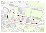
A number of large opportunity sites have been identified and designated in this plan. The development of these are of prime importance to the economic regeneration and urban fabric enhancement of the town. These sites include The Island of Geese Site, Balloonagh Convent, John Joe Sheehy Road, lands adjacent to Dan Spring Rd, lands adjacent to Ballymullen Roundabout and lands adjacent to Clash Rd. This broad selection of land provides greater choice for potential developers/ investors. In addition to the conventional zoning of land for employment uses, opportunities for the provision for mixed use urban development has been identified. Retail or retail warehousing uses will not be permitted on these sites.
A number of the sites available for development contain protected structures. It is preferable that these are developed and occupied rather than remain vacant and prone to dereliction and vandalism. In view of this the Planning Authority will actively promote and facilitate the sustainable re-development and re-use of these structures and sites.
Archaeological test excavation and subsurface ground testing of the sites shall be carried out prior to the carrying out of any development.
| Opportunity Sites | ||||
| Location | Map and Description | Site Size | Development Potential | Zoning |
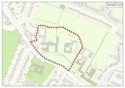
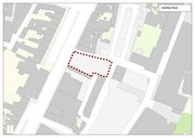
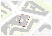
| Balloonagh Convent |
Large Landmark building (protected structure) with associated brownfield site. |
3.4ha | Significant mixed-use development, including health care and assisted living facilities | M1 |
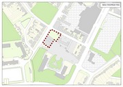
| Dan Spring Road |
Edge of town riverside site. |
2.3ha | A new mixed-use urban streetscape providing new Conference Hall facilities. | C5 |
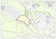
| Ballymullen Roundabout |
This site which has a large river frontage is also within close proximity to the town park. |
1.4ha | A new landmark building incorporating a mixed-use with office space. | M1 |
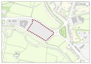
| Lands fronting onto/adjacent to Clash Road |
Large vacant brownfield site adjacent to the former Tralee Racecourse. |
5.8ha | The redevelopment of this large industrial brownfield site as a new mixed-use development. | M1 |
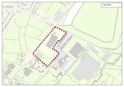
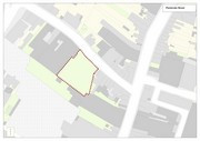
| John Joe Sheehy Road |
Large brownfield site with infill sites. |
3.5ha |
A new mixed-use urban streetscape providing residential and commercial use. A coordinated approach is required due to multi ownership. |
M1 |
1.5.2 Other Opportunity Sites
A number of small opportunity sites have been identified, the development of these site are of importance to regeneration of the urban fabric and public realm in the town. These sites include a number of smaller brownfield sites situated off James St/Basin View, Pembroke Street, Godfrey Place (former Cameo bakery), Kelliher’s Mills. The local authority will encourage the redevelopment of these sites throughout the town on a case-by-case basis.
|
|
|
|
Map 1.8: Smaller Opportunity sites
Development Potential
Desirable re-development of these sites includes a mix of residential units, tourist related services, small scale tourist accommodation, small scale office development. New buildings shall generally be three to four storey, simple and consistent in design with the traditional streetscape. Sensitive contemporary design is open to consideration. A design brief will be required of any proposal demonstrating the rationale for the proposed design chosen by the developer.
|
Opportunity Sites It is an objective of the Council to: |
|
|
TR 41 |
Facilitate and/or require the preparation of masterplans for the Opportunity sites and the Lohercannon Area where appropriate prior to the redevelopment of opportunity sites identified in the plan to ensure their development in a cohesive and integrated manner. |
|
TR 42 |
Require the carrying out of archaeological test excavations and ground testing prior to the re-development of opportunity sites identified. |
1.5.3 Lohercannon Area
The Council intend to prepare a masterplan to guide and facilitate the development of the Lohercannon area in a co-ordinated manner to provide a new residential and community/educational quarter that prioritises walking, cycling and permeability between area and the Town centre maximising the existing and proposed routes, planned cycleways and new civic spaces.