3.5 Sustainable Land Use Development
3.5 Sustainable Land Use Development
In accordance with RPO 43 Regeneration, Brownfield and Infill Development a number of sites have been identified for potential redevelopment. An increased level of density will be permitted on these sites subject to appropriate design and integration. Additional incentives to development these lands also apply such as reduced development contributions and parking requirements.
It is a policy of this plan that developments in Listowel shall have regard to the Ministerial Guidelines regarding Sustainable Urban development, building heights apartment size etc, the Council will have a flexible design led approach to development within these designated regeneration sites.
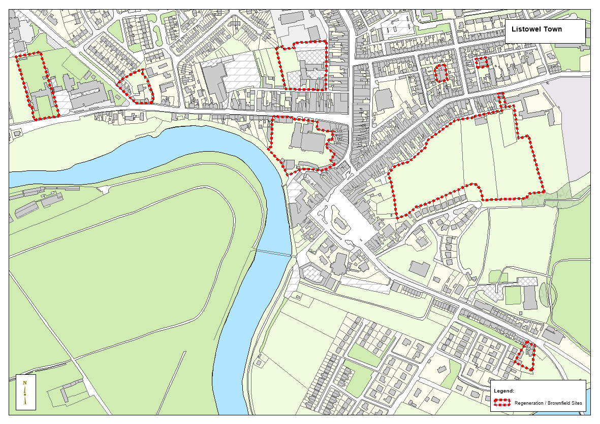
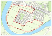
Map 3.2: Town Centre Opportunity Sites
|
Regeneration Areas Objectives It is an objective of the Council to: |
|
|
LIS 32 |
Facilitate and support the Housing Policy Objectives, address vacancy in housing in the Housing for All Plan DoHLG 2021. |
|
LIS 33 |
Facilitate the regeneration of vacant and underutilized sites/buildings in the town centre area identified in Map 3.1. |
|
LIS 34 |
Implement the Town Centre First Approach as a mechanism to regenerate and sustain the urban core area. |
3.5.1 Opportunity Sites
A number of large opportunity sites have been identified in the town (see Town Centre Map). The development of these are of prime importance to the economic regeneration and urban fabric enhancement of the town. These sites include the former Mart site, lands to the south of Church Street and the former Convent site on Convent Road. This broad selection of land provides greater choice for potential developers and investors. In addition to the conventional zoning of land for employment uses, opportunities for the provision for mixed use urban development have been identified.
These lands collectively therefore offer a significant opportunity for regeneration with mixed -use and residential development in central location. The fragmented pattern of landownership in these areas, however, makes the co-ordinated development of these areas challenging. To maximise the potential of these undeveloped and brownfield lands it is essential that a detailed Master Plan is prepared for these sites. These Master Plans will take cognisance of the town centre location, planned cycleways and new civic spaces to provide a planning framework to enable a new sustainable residential urban quarter that prioritises walking, cycling and permeability to surrounding areas. These plans shall also include Traffic Impact assessment.
|
Opportunity Sites |
||||
|
Location |
Map |
Site Size |
Development Potential |
Zoning |
|
Former Mart Site |
|
1.2ha |
Focal town centre location
Mixed retail & residential use |
M1 |
|
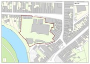
Rear of Church Street |
|
4.2ha |
Large backland site |
M1 |
|
Former Convent Site |
|
0.9ha |
Historical building
Mixed tourism or community, educational |
M4 |
3.5.2 Regeneration Sites/Lands
A number of other sites have also been identified, the development of which are of significant importance to the regeneration of the urban fabric and public realm in the town. These sites include a number of brownfield sites situated at Brennan’s sheds – Upper Church Street, at the rear of Market Street and Charles Street. The Local Authority will encourage the redevelopment of these sites throughout the town on a case-by-case basis.
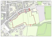
3.5.3 Castleinch
The development of the Castleinch lands also offer a significant opportunity for regeneration.
The area along the river edge and contiguous to the town centre which, if combined offers significant potential for development that harness its prime location in the town. The council will require the preparation of a masterplan/design brief where appropriate prior to the redevelopment of the Castleinch lands for the development of a landmark riverfront site in a sustainable manner, providing new mixed use/ tourist facilities subject to a flood risk assessment in accordance with ‘The Planning systems and Flood Risk Management - Guidelines for Planning Authorities’, compatibility with the conservation objectives of the Lower River Shannon SAC and a traffic impact assessment. The Castleinch lands could be developed to supplement the tourist offerings in the Square and could provide a link between the square and the outdoor activity facility hub at the former Neodata site.
|
Location |
Map |
Site Size |
Development Potential |
Zoning |
|
Castleinch |
|
9.4ha |
Mixed tourism (Subject to SFRA) |
O1 |
|
Opportunity Sites Objectives It is an objective of the Council to: |
|
|
LIS 35 |
Require the preparation of masterplans prior to the redevelopment of all opportunity sites identified in the plan. |
|
LIS 36 |
Require the preparation of masterplans/design briefs where appropriate prior to the redevelopment of the Castleinch lands for the development of a landmark riverfront site in a sustainable manner, providing new mixed use/ tourist facilities, subject to a flood risk assessment in accordance with ‘The Planning systems and Flood Risk Management - Guidelines for Planning Authorities’ and compatibility with nature conservation objectives for the Lower River Shannon SAC. |