Please find submission attached which ids a general submission to the plan.
Chapter 3: Core & Settlement Strategy
Closed6 Dec, 2021, 00:01 - 23 Feb, 2022, 17:01
Contents
3.2 Setting out the Core Strategy
3.3 Context - National and Regional Policy
3.4 Principles of the Core Strategy
3.6 Layout and Content of the Core Strategy
3.7 Sustainable Countywide Development
3.8 Population Projections & Spatial Distribution
3.11 The Zoning of Land for Residential Development
3.12 Housing Need Demand Assessment (HNDA)
_________________________________________________________________
3.0 Core & Settlement Strategy
3.1 Introduction
This Chapter sets out the Core Strategy which is the settlement and growth strategy for the entire County. The Core Strategy is the key component of the County Development Plan. It sets out, in line with the overarching hierarchy of national and regional plans, and the Development Plan Core principles, the quantum and location of development in the County over the lifetime of the Plan. This will provide for the development of County Kerry as an attractive, competitive, and sustainable place where the quality of its economy, natural and built environment, culture and the strength and viability of its communities are of the highest standards.
3.2 Setting out the Core Strategy
The purpose of the Core Strategy is to set out an evidence-based strategy for the future spatial development of the Plan area. The Core Strategy is required to demonstrate that the Plan is in accordance with National and Regional planning policy outlined in the National Planning Framework (NPF) and the Regional Spatial and Economic Strategy (RSES) for the Southern Region, as far as practicable.
The plan complies with the RSES Strategy Statements by:

|
Strengthening and growing our towns and villages through quality development; regeneration and compact growth; building on the strong network of towns and supporting our villages and rural areas |
| 1. Compact Growth | |

|
Enhancing regional and county accessibility through upgraded transport infrastructure and digital connectivity allied to transformed settlement hierarchy |
| 2. Enhanced Regional Accessibility | |

|
Strengthening the role of and improving quality of life in the County’s diverse rural areas and communities and valuing our rural areas as dynamic, resilient, and outward looking. |
| 3. Strenghtened Rural Economies & Communities | |

|
Transforming our transport systems towards well-functioning, sustainable integrated public transport, walking and cycling and electric vehicles |
| 4. Sustainable Mobility | |

|
Building a competitive, innovative, and productive economy. |
| 5. A Strong Economy | |

|
Optimising our international connectivity through investment and increased capacity in Fenit port and Kerry Airport and provision of high-quality digital connectivity throughout the County and wider region. |
| 6. High-Quality International Connectivity | |

|
Strengthening and protecting our County’s diversity, language and culture, our recreational assets, and our natural and built heritage |
| 7. Diversity, Language, Culture & Heritage Enhancement | |

|
Safeguarding and enhancing our environment through sustainable development, prioritising action on climate change across the Region and County, driving the transition to a low carbon and climate resilient society |
| 8. Low Carbon, Climate Resilitent & Sustainable Society | |

|
Outlining a strategy for development and services in a sustainable, planned and infrastructure-led manner to ensure the sustainable management of water, waste and other environmental resources |
| 9. Sustainable, Planned & Infrastructure-led Development | |

|
Achieving improved education, health and public services and facilities for all citizens and communities |
| 10. A Healthy & Learning Region | |

|
Building an inclusive outward looking county within an international region on the global stage |
| 11. Inclusive International Region |
The Core Strategy includes details of the settlement hierarchy and where future growth is to be distributed in the County together with details of population and household projections.
By 2031, the population of the County will most likely grow by 19,000-23,000 people to reach a potential population of 170,500 people[1]. This growth will require new homes and new jobs. It raises questions as to where our future population will live and work, what kind of quality of life will we enjoy and how we can adapt to the challenges we face such as climate change, county and regional disparity and global uncertainty.
This Plan is underpinned by a strategic vision which is intended to guide the future development of the County in a sustainable manner, in a way that reflects the existing character and amenities of the county and improves quality of life for the existing and future population.
In line with this the promotion and consolidation of the towns and villages of the plan through reuse, restoration and regeneration, and the creation of a vibrant urban form, resulting in settlements that are attractive places in which to live, work and visit is essential. The regeneration of the urban core of towns and villages will set the framework for the creation of a sustainable economic base to facilitate integrated communities while balancing future development with the conservation and enhancement of the natural and built environment of each settlement and surrounding areas.
The following will be prioritised to achieve the vision of the County Development Plan:
- Emphasis will be on the settlements outlined in the settlement strategy as the principal locations for future investment in housing, employment, infrastructure, social and community facilities.
- Re-positioning of settlements as the focal point for services serving their surrounding rural hinterland. The level of service provision will be commensurate with the size of settlement, infrastructural provision and demand from the rural hinterland served.
- The County’s intrinsic qualities, including social, recreational, cultural, linguistic, and environmental assets, will be protected which when combined with high quality employment opportunities will provide a unique location and quality of life for the residents and visitors.
- The provision of adequate water and wastewater infrastructure to facilitate the sustainable development of towns and villages without adverse impact on the environment.
- The creation of employment opportunities, capitalising on the roll out of the National Broadband Scheme and societal shifts towards remote working.
3.3 Context – National and Regional Policy
What Project Ireland 2040 and the RSES means for the Southern Region and for County Kerry
The NPF projects that the population of the Region will grow by 380,000 to almost 2 million by 2040, with around 225,000 additional people in employment. There will be between 196,000 and 235,500 additional people up to 2026 and between 280,000 and 343,500 up to 2031 living in the region. This will require up to 86,000 new homes by 2026 and 125,000 by 2031. Additionally, to cater for our changing population additional housing responses will be required including a requirement to provide a social housing mix, facilitate upgrading and replacement of older and poor-quality stock and provide housing for smaller families and an ageing population.
The NPF places an emphasis on consolidating and compacting the development of places that grew rapidly in the past decade or so with large scale commuter driven housing development. It also has a focus on addressing local community and amenity facility provision through targeted investment and town, village, and rural rejuvenation through the Urban and Rural Regeneration and Development Funds.
The RSES recognises the strategic role played by all areas, both urban and rural, in achieving the set regional and national targets and objectives. The RSES also supports sustainable enterprise growth, services, physical and social infrastructure investment, and the sustainable growth of all communities in the Region. The overall strategy builds on cities and their associated metropolitan areas as engines of growth and seeks, in parallel, to re-position the Southern Region’s strong network of towns, villages and diverse rural areas in an economically resilient, imaginative, and smart way to foster sustainable competitive advantage.
It is a mandatory requirement that there is consistency in the spatial planning hierarchy between national, regional, and local plans. The County Development Plan will therefore be aligned, in so far as is practicable, with the national and regional policy objectives set out in the NPF and RSES.
|
|
2016 |
2026 |
2031 |
|
Mid-West |
385,000 |
436,000-446,000 |
460,500-475,500 |
|
South-East |
509,500 |
561,000-572,000 |
581,500-598,500 |
|
South-West |
690,500 |
784,000-802,500 |
823,000-854,500 |
|
Total |
1,585,000 |
1,781,000-1,820,500 |
1,865,000-1,928,500 |
|
Kerry |
147,500 |
161,000-163,500 |
166,500-170,500 |
Table 3.1: Regional Distribution of Growth (RSES)
3.4 Principles of the Core Strategy
The Core Strategy considers all aspects of what is needed to deliver sustainable communities having regard also to the availability of infrastructure, the carrying capacity of the environment and the need to support economic development. The following are the key areas considered in the preparation of the Core Strategy:
Climate Action and Renewable Energy - To transition to a low carbon and climate resilient county, with an emphasis on reduction in energy demand and greenhouse gas emissions, through a combination of effective mitigation and adaptation responses to climate change; whilst increasing the resilience of our Natural and Cultural Capital to climate change by planning and implementing appropriate adaptation measures.
Housing - To facilitate the sustainable growth of all rural areas, towns and villages throughout the county by seeking to accommodate, as far as possible, all persons in their choices to live in our rural areas, towns and villages; by supporting and strengthening the rural economy to sustain vibrant rural communities and by promoting consolidation and compact development of all urban and rural settlements in an attractive setting that provides a suitable mix of housing with supporting amenities; and by ensuring coordinated investment in infrastructure that will support economic competitiveness and create a high quality living and working environment.
Settlements - To develop Kerry's settlements as a network of attractive, liveable towns and villages in the county with sustainable levels of population, employment activity and enhanced levels of amenity which encourage a high quality of life and well-being and support a sustainable synergy with the rural countryside.
Key Towns - To prioritise the sustainable development of the Key Towns of Tralee and Killarney within the Kerry Hub and Knowledge Triangle in line with the RSES.
Sustainable Communities - To develop and support vibrant sustainable communities in Kerry where people can live, work, and enjoy access to a wide range of community, health, educational facilities, and amenities, suitable for all ages and needs, in both urban and rural areas, thereby supporting a high quality of life for all to enjoy.
Economic Development - To promote and enhance Kerry’s economic development potential through increased resilience in the county’s enterprise, underpinned by talent and innovation, thereby ensuring that Kerry is best placed to excel in the long-term delivery of sustainable jobs and an enhanced standard of living for all.
Kerry Hub and Knowledge Triangle - To seek investment for and to facilitate development within the Kerry Hub and Knowledge Triangle as the economic core of the county.
Tourism Development - To develop Kerry as the leading tourism destination through continued sustainable expansion of the tourism sector, with a focus on creating high-quality visitor services and the continued development and enhancement of visitor attractions and activities, capitalising on our natural and cultural heritage assets, whilst safeguarding these resources for future generations.
Mobility and Transport - To support increased use of sustainable modes of transport; the integration of spatial planning with transport planning; enhanced county and regional accessibility; the transition to a low carbon energy efficient transport system; and the development of a safer, more efficient, effective, and connected transport system within Kerry.
Infrastructural Development - To protect, improve and provide water, wastewater, surface water and flood alleviation services throughout the county, and to facilitate the provision of high-quality information communication technology, broadband, telecommunication information and electricity network required to support and enhance the key aims of best place to live, work, visit and invest.
Built Environment - To recognise and enhance the unique identity, character and built heritage of Kerry's towns, village, and rural areas, to improve quality of life through the application of healthy placemaking, underpinned by good urban design with the creation of attractive public spaces that are vibrant, distinctive, safe, and accessible and which promote and facilitate positive social interaction.
Natural Environment - Continue to protect and enhance the county’s natural heritage and biodiversity and ensure that networks of green and blue infrastructure are identified, created, protected and enhanced to provide a wide range of environmental, social and economic benefits to communities; To also improve the knowledge and understanding of the county’s landscape and coast, and enhance the overall characteristics, qualities and diversity of landscape character, its sense of place and local distinctiveness in recognition of the amenity potential of the county.
Funding - To maximise and utilise all available funding streams to implement the objectives of this plan. Promote the sustainable implementation of innovative, collaborative projects through the URDF, the RRDF and other sources of EU and national funding.
|
Strategic Principles of the Core Strategy |
|
|
It is an objective of the Council to: |
|
|
KCDP 3-1 |
Promote the Sustainable Development of the County in line with the Strategic Core Principles of the Core Strategy. |
3.5 Core Strategy Map
The Core Strategy Map (Map 3.1) set out below provides a conceptual overview of the spatial planning strategy for the County. This map illustrates the designated growth centres and strategic transport corridors in the county, set within the context of the wider region.
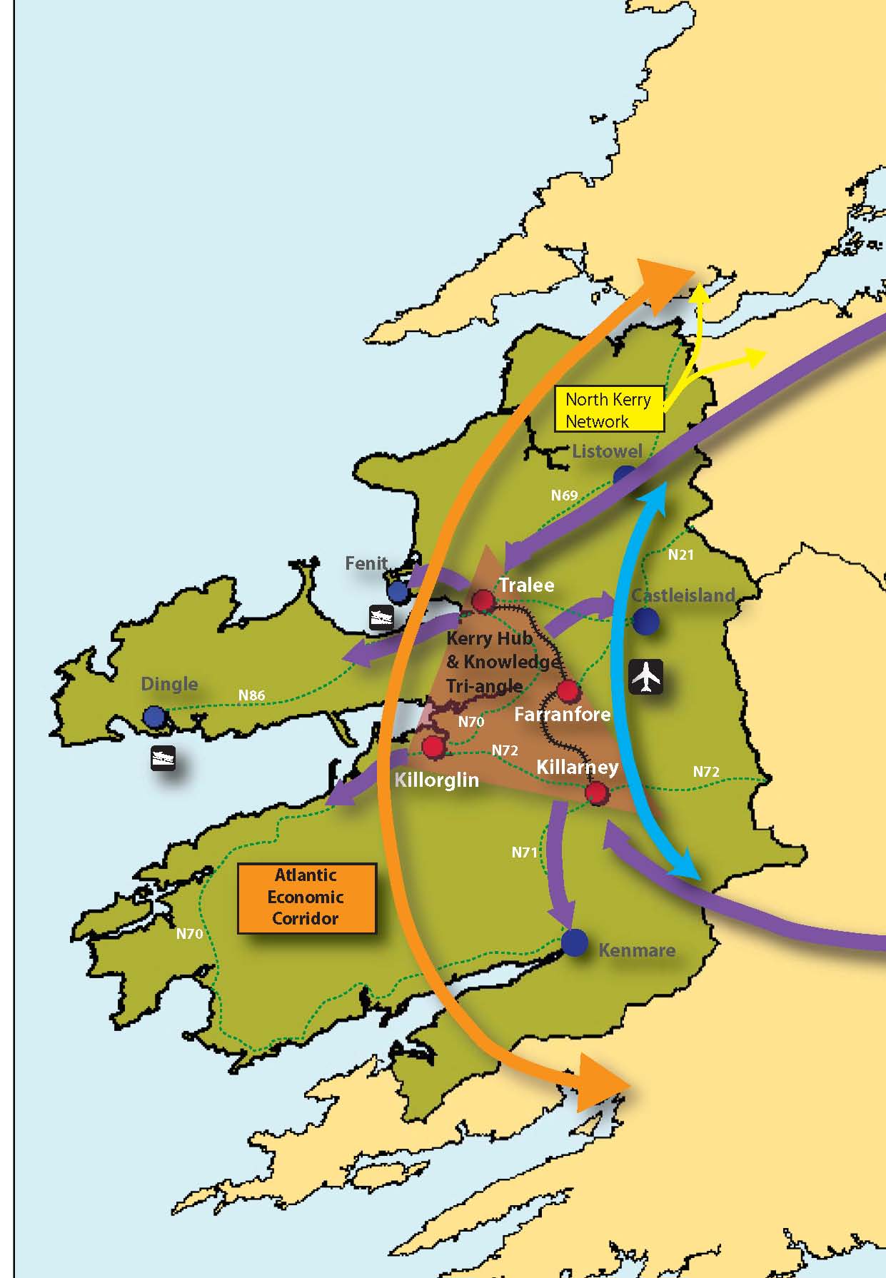
Map 3.1: Core Strategy Map (click to enlarge)
3.5.1 Strategic Economic Drivers within County Kerry
The core and settlement strategies are shaped by the key strategic economic drivers within the county and the wider region. These strategic economic drivers have the potential to drive real transformational change for Kerry, making the county one of the most attractive places to live, work, invest and visit in Ireland. Map 3.1 above illustrates the spatial influence of the strategic economic drivers for County Kerry. The map highlights the influence of the Atlantic Economic Corridor, Kerry International Airport and the Kerry Hub and Knowledge Triangle to the county.
3.5.1.1 Atlantic Economic Corridor (AEC)
Kerry is strategically located along the Atlantic Economic Corridor (AEC). The AEC aims to combine the economic hubs, clusters, and catchments of the area to attract investment, improve competitiveness, support job creation, and contribute to an improved quality of life for the people who live there. The AEC has significant potential for future economic growth of/in County Kerry and the wider region. The advancement of Kerry’s economic growth clusters; Ireland Kerry International Airport, key capital infrastructural projects under Project 2040; and the potential future opening of the Southern greenway will all consolidate the AEC. The success of the AEC initiative will attract more enterprise and people to the county and the region, progressing balanced regional development, whilst sustaining strong and vibrant communities.
3.5.1.2 Key Towns and Regional Towns
The economic development of Kerry will be further enhanced through the development of its two key towns (Tralee / Killarney) and eight regional towns (Ballybunion, Cahersiveen, Castleisland, Dingle/Daingean Uí Chúis, Kenmare, Killorglin, Listowel, Milltown). These towns seek to harness and develop the complementary strengths and synergies between the settlements and their functional hinterland, to create highly connected centres of scale, with the necessary critical mass, in terms of population and employment, to enable them to compete and grow to fulfil their potential and drive regional development in tandem with regional and national policy.
3.5.1.3 Kerry Hub and Knowledge Triangle
The Kerry Hub and Knowledge Triangle is identified in the Regional Spatial & Economic Strategy (RSES) as an economic driver for the Region and its future growth is key to the sustainable development of the county through the provision of employment opportunities, high level training and research opportunities as well as being a catalyst for further economic activity in the more peripheral areas of the county.
3.5.1.4 North Kerry/West Limerick/Shannon Estuary/Clare Settlement Network
Kerry County Council supports the economic role and potential of the established towns of Listowel, Abbeyfeale, Newcastle West (Key Town) and Kilrush as economic drivers in a potential North Kerry/West Limerick/Clare network connected with the Shannon Estuary. This includes the Shannon Integrated Framework Plan (SIFP) area and strategic locations identified under the SIFP as a Shannon Estuary Coastal Network.
3.5.1.5 Kerry International Airport
Kerry International Airport acts as a magnet to draw people and investment to the county and the region, driving economic activity in the form of business and investment as well as tourism and travel.
3.6 Layout and Content of the Core Strategy
The content of Core Strategies is set out in Section 10 of the Planning and Development Act and must include:
- Population Targets,
- Future household targets and quantification of requirements for zoning of lands for residential and or a mix of residential and other uses; and
- Proposed existing and future distribution of population within the plan area within a settlement hierarchy.
3.7 Sustainable Countywide Development
This Plan identifies the importance and key role of Kerry’s rural communities in contributing to positive growth and economic development throughout the County.
County Kerry’s rural communities are an asset to be valued and nurtured. The diversity in the opportunities that our rural communities give rise to is significant and has the potential to differentiate the County from other places, particularly in terms of the quality of life offering that is available. The County’s towns and villages are at the centre of rural communities because they are important locations for service delivery, gathering, expression of identity, rural enterprise and social and community supports. This Plan recognises the importance of rural towns and villages in supporting the wider rural community and therefore seeks to enable their revitalisation and regeneration as a key strategic intervention. To this end, the Core Strategy of the Plan, targets some 54% of the projected population growth towards that part of the County outside Tralee and Killarney.
This approach is consistent with national policy (the NPF) and in particular through the Governments publication, ‘Realising Our Rural Potential - Action Plan for Rural Development’ (January 2017). This Action Plan highlights the vital role that rural Ireland plays in shaping Irelands economic success and aims to unlock the potential of rural Ireland’s positive attributes through a framework of supports at National and local level.
Villages and small village settlements play an important role and provide vital services in every rural area. Rural areas identify with these particular settlements, hence the identification and inclusion of a number of small village settlements throughout the county.
3.8 Population Projections & Spatial Distribution
Census 2016 indicated that the population of County Kerry was increased from 145,502 in 2011 to 147,707, an increase of 1.5%. This percentage increase was amongst the lowest in the State, with the State showing an overall increase of 3.8% over the same period. These increases show a significant reduction in growth compared to the previous intercensal period (2006-2011) where Kerry’s population increased by 4.1%.
The population increase between 2011 and 2016 is dispersed across the county. The more peripheral areas to the west and south west of the County and parts of the north and east experienced population decline while the EDs adjacent to the towns of Tralee and Killarney, Kenmare and Killorglin experienced the highest levels of growth.
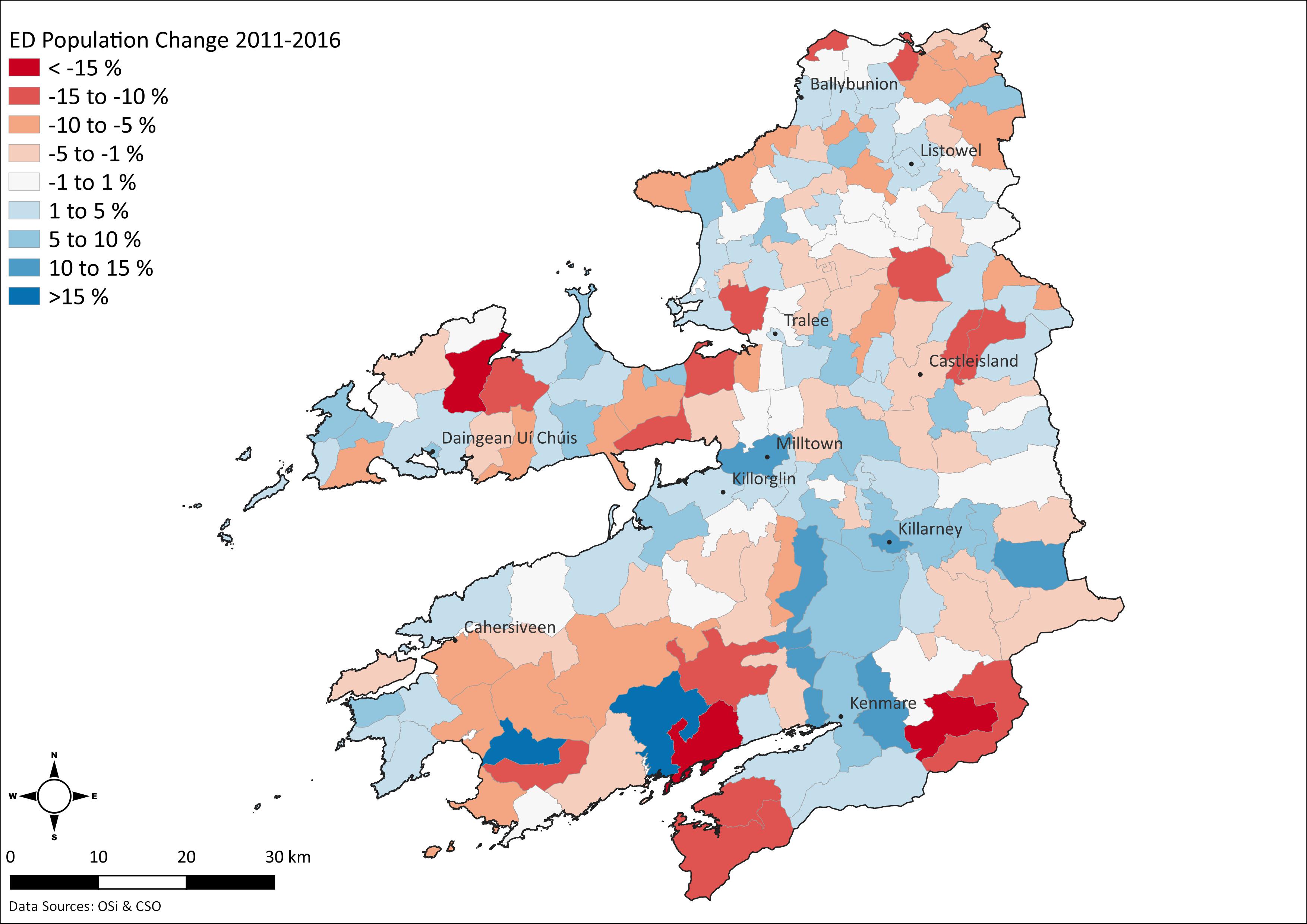
Map 3.2: Population Change 2011-2016 (click to enlarge)
3.9 Future Population Growth
3.9.1 Population Growth
The population projections for County Kerry are detailed in Table 3.2 below. Population growth projections contained in Appendix 1 of the RSES and Appendix 2 of the Implementation Roadmap for the NPF, have formed the basis for the population and growth predications for the future development of the County, which has been included in this Development Plan. The NPF/RSES figures have been extrapolated to work out the population projections in the county between 2022 and 2028.
|
|
2011 Census |
2016 Census |
2026 |
Uplift 2016 to 2026 |
2031 |
|
Population |
145,502 |
147,707 |
161,000 - 163,500 |
13,500 - 16,000 |
166,500 - 170,500 |
Table 3.2: Population Projections (NPF/RSES)
As indicated in this table the NPF/RSES indicate higher and lower population projections for Kerry to 2026 and 2031. The lower of the 2026 projected figures would see a 9% increase on the population of the county in 2016, with the higher figure seeing the county’s population increase by 11%. There is a pressing need to increase national housing supply to meet existing, unmet demand, to the greatest extent possible in the shortest time possible, while also accommodating projected national housing demand. In the context of the housing supply target as shown in Table 3.4, the higher population projection is considered appropriate.
Table 3.3 extrapolates this population projection and apportions it to 2028, intended duration of the CDP.
|
|
2022 |
2028 |
Total Uplift 2022 to 2028 |
|
Population |
156,902 |
166,265 |
9,363 |
Table 3.3: Kerry Population Projections 2022-2028
3.9.2 Housing Growth
In the Housing Supply Target Methodology for Development Planning Guidelines (December 2020), planning authorities must provide for housing in their development plan that is consistent with national and regional planning objectives, including the achievement of compact growth and the consolidation of towns and cities, in order to move away from a development pattern characterised by dispersed sprawl and unsustainable levels of long-distance commuting.
County development plans must therefore plan to provide housing to the extent identified in the established NPF Roadmap population projections for their local authority and in accordance with the NPF 50:50 scenario as set out in the Housing Supply Target Methodology for Development Planning Guidelines for Planning Authorities (December 2020). These guidelines place an obligation on Planning Authorities to take into consideration (in addition to the NPF population projections) household demand, actual new housing supply since 2017 and homeless households. Detailed information in relation to these factors has been provided by the ESRI and taken into consideration in the Core Strategy.
|
|
|
Total Households |
|
A |
ESRI NPF scenario projected new household demand 2017 to Q3 2028 (plan end) |
7,279 |
|
B |
Actual new housing supply 2017 to Q2 2021 |
1,934 |
|
C |
Homeless households and unmet demand |
192 |
|
D |
Plan Housing Demand {(A+C)-B} |
5,537 |
|
E |
Adjustment to end 2026 portion of plan period to facilitate convergence to NPF strategy |
|
|
E1 |
ESRI Baseline scenario new household demand 2017 to end 2026 |
9,155 |
|
E2 |
ESRI NPF scenario projected new household demand 2027 to Q3 2028 (plan end) |
1,050 |
|
E3 |
Mid-point between E1 and A-E2 (ESRI NPF and Baseline scenarios to end 2026) |
7,692 |
|
E4 |
Adjusted Total Plan Demand {(E2+E3+C)-B} |
7,000 |
Table 3.4: Methodology for the application of NPF population and housing projections
This housing demand has been divided across the settlements of the County in proportion to projected population growth as per the Core Strategy.
3.9.3 Headroom
The transitional population projections set out in Appendix 2 of the Implementation Roadmap for the NPF includes ‘headroom’ provision. Further ‘headroom’ not exceeding 25% can be considered in counties where population growth is projected to be at or above the national average baseline. Kerry is not included in the list of counties where this additional ‘headroom’ can be applied.
|
Core Strategy |
|
|
It is an objective of the Council to: |
|
|
KCDP 3-2 |
Support the sustainable growth and prioritise development of the county’s settlements in accordance with the Settlement Hierarchy and the Core Strategy. |
|
KCDP 3-3 |
Identify and support investment opportunities with infrastructure providers to deliver the Core Strategy. |
3.10 Settlement Strategy
A strong network of settlements is important for sustaining healthy population levels and enhancing quality of life. This section identifies the different settlements throughout the County having regard to their areas of influence and their strategic roles for the future.
3.10.1 Principles of the Settlement Strategy
The main principles of the Settlement Strategy are to:
- Ensure the sustainable development of the Key towns of Tralee & Killarney to fulfil the roles identified in the Regional Spatial and Economic Strategy.
- Ensure the sustainable development of a network of towns and villages in the county to act as service and employment centres for the surrounding hinterland.
- Facilitate the provision of housing and services having regard to settlement type.
- Facilitate the sustainable future development of infrastructure to serve identified settlements.
3.10.2 Settlement Hierarchy
Section 3.3 of the RSES includes a settlement typology which sets out the settlement structure for the Southern Region. This settlement typology identifies the Cities/Metropolitan Areas and Key Towns including Tralee and Killarney. The position of the remaining settlements in this typology had regard to the criteria set out in section 3.3 and to the following:
- Recent trends in population, employment, the level of services available in the settlements.
- Accessibility and geographical influence in a regional/sub-regional and county context.
- Character of local geography and accessibility as a service centre for remote and long-distance rural hinterlands.
- Infrastructure provision or planned infrastructure investment and their ability and appropriateness to accommodate future growth.
|
Settlement Type |
Description |
|
Key Town |
Large population scale urban centre functioning as self-sustaining regional drivers, and strategically located urban centres with accessibility and significant influence in a sub-regional context. |
|
Regional Town |
Towns which provide a housing, employment, or service function. The category is broad and ranges from large commuter towns to more peripheral towns. |
|
District Town |
Towns that serve a rural hinterland as service centres. |
|
Village |
Smaller settlements that serve a rural hinterland with less of a variety of services available. |
|
Small Village Settlements |
Serve smaller rural catchments. They provide local services with some smaller scale rural enterprises in a number of such villages. |
Table 3.5: Settlement Types
|
Hierarchy |
Settlement |
|
|
Key Towns |
|
|
|
Regional Towns |
|
|
|
District Towns |
|
|
|
Villages |
|
|
|
Small Village Settlements |
|
|
Table 3.6: Settlement Hierarchy
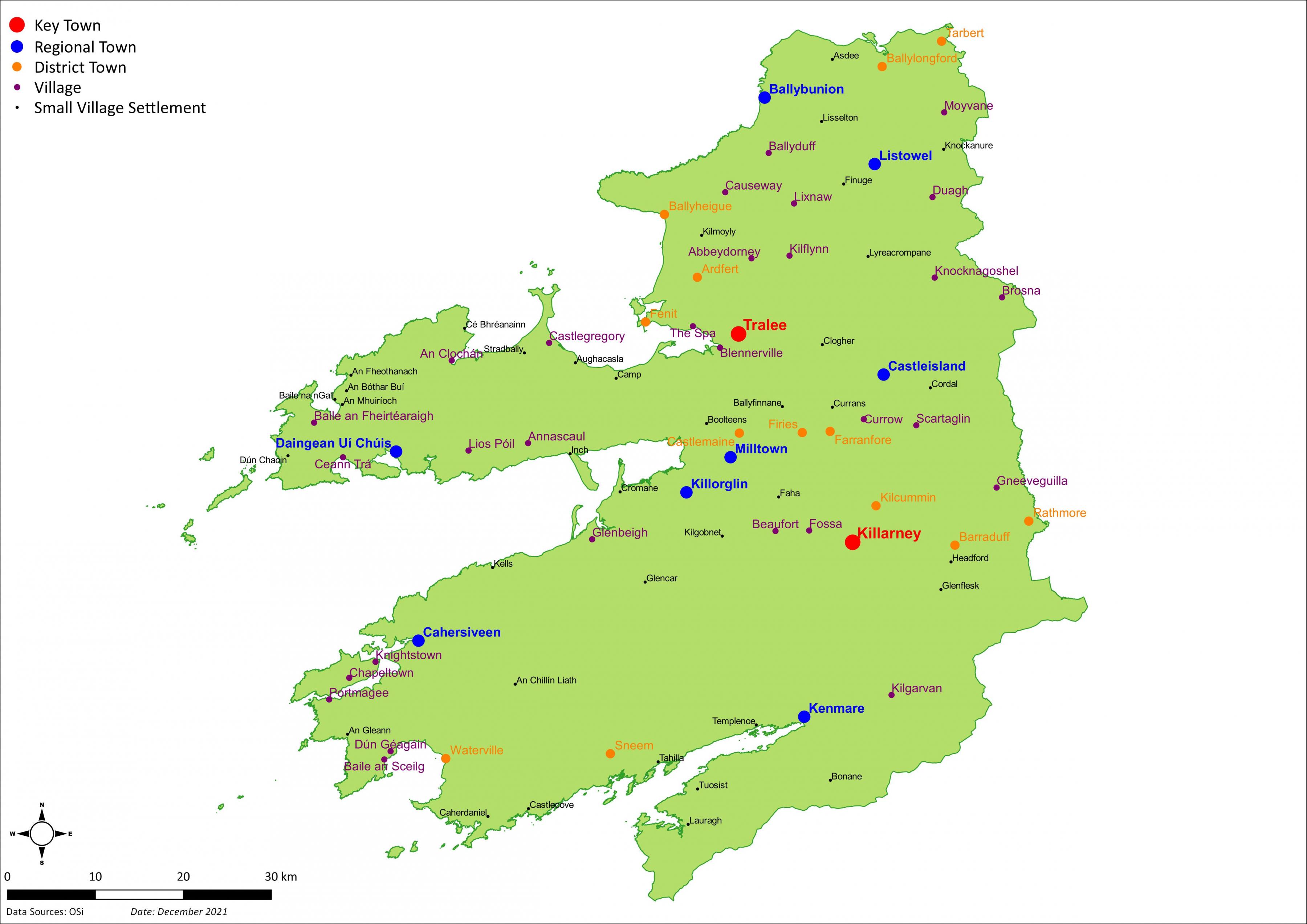
Map 3.3. Settlements (click to enlarge)
|
Settlement Strategy |
|
|
It is an objective of the Council to: |
|
|
KCDP 3-4 |
Deliver at least 30% of all new homes in the Key Towns of Tralee and Killarney within the existing built-up footprint of the settlements. |
|
KCDP 3-5 |
Strengthen the social and economic structure of rural towns and villages by supporting the re-use of existing buildings and the regeneration of under-utilised buildings and lands. |
3.10.3 Population Distribution
The population growth allocation for Tralee and Killarney is 4,293. This growth allocation will ensure that these Key Towns will grow by over 30% by 2040 (in accordance with the RSES) positioning these settlements as sufficiently sized urban zones to attract additional employment and population, which will increase their competitiveness and attractiveness as national and regional investment locations.
|
Settlement |
Population & Housing |
||||
|
|
Population 2016 (CSO) |
Population 2022 (est.) |
2022-2028 Pop. Growth |
Housing Target |
|
|
County |
|
147,707 |
156,902 |
9,363 |
7,000 |
|
Key Town |
Tralee |
23,691 |
25,297 |
2,663 |
2,087 |
|
Killarney |
14,504 |
15,487 |
1,630 |
1,277 |
|
|
|
38,195 |
40,784 |
4,293 |
3,364 |
|
|
Regional Town |
Listowel |
4,820 |
5,127 |
529 |
415 |
|
Castleisland |
2,486 |
2,644 |
359 |
281 |
|
|
Kenmare |
2,376 |
2,527 |
261 |
204 |
|
|
Killorglin |
2,199 |
2,339 |
320 |
251 |
|
|
Dingle/Daingean Uí Chúis |
2,050 |
2,181 |
282 |
221 |
|
|
Ballybunion |
1,413 |
1,503 |
204 |
160 |
|
|
Cahersiveen |
1,041 |
1,107 |
129 |
101 |
|
|
Milltown |
928 |
987 |
273 |
214 |
|
|
|
17,313 |
18,417 |
2,357 |
1,847 |
|
|
District Town |
Ardfert |
749 |
797 |
78 |
61 |
|
Ballyheigue |
724 |
770 |
77 |
60 |
|
|
Ballylongford |
391 |
416 |
45 |
35 |
|
|
Barraduff |
170 |
308 |
57 |
45 |
|
|
Castlemaine |
176 |
187 |
37 |
29 |
|
|
Farranfore |
175 |
186 |
42 |
33 |
|
|
Fenit |
538 |
572 |
130 |
102 |
|
|
Fieries |
558 |
594 |
46 |
36 |
|
|
Kilcummin |
435 |
463 |
40 |
31 |
|
|
Rathmore |
790 |
840 |
73 |
57 |
|
|
Sneem |
288 |
306 |
27 |
21 |
|
|
Tarbert |
540 |
574 |
57 |
45 |
|
|
Waterville |
462 |
491 |
52 |
41 |
|
|
|
5,996 |
6,505 |
761 |
596 |
|
|
Villages |
|
6,698 |
7,125 |
552 |
432 |
|
Small Village Settlements |
|
1,547 |
1,646 |
465 |
186 |
|
Rural Area |
|
77,958 |
82,425 |
936 |
575 |
Table 3.7: Population & Housing Growth 2022-2028
In allocating future population growth to other settlements, the following guiding principles were considered:
- Scale of population and its existing performance.
- Scale of employment provision, number of jobs, jobs-to-resident worker’s ratio, and net commuting flows; Balance between population growth and employment provision.
- Compliance with the NPF (NPO 72) on a standardised, tiered approach that differentiates between zoned land that is serviced and that which is serviceable within the life of the plan.
- Linking Core Strategies to an evidence base on the availability and deliverability of lands within the existing built-up footprints.
- Extent of local services and amenities including education, health, leisure, and retail.
- Extent to which sustainable modes of travel can be encouraged (walking, cycling or public transport).
- Rate and pace of past development and the extent to which there are outstanding requirements for infrastructure and amenities.
- Accessibility and influence in a regional/sub-regional/county context.
- Character of local geography and accessibility as a service centre for remote and long-distance rural hinterlands.
- Environmental and infrastructural constraints.
- The appropriate density and scale of development relative to the settlement and location, incl. differing rates and nature of development experienced.
- Need for attractive, alternative options to rural housing within smaller towns and villages.
The remaining population growth of 5,070 is allocated to other towns in the County and the rural area. This will ensure that development in these towns is commensurate with the scale of these towns and the provision of additional employment.
3.11 The Zoning of Land for Residential Development
The zoning of lands in the current Municipal District / Electoral Area Local Area Plans (LAP’s) is consistent with the existing and proposed core strategy.
These LAP’s will be updated/replaced over the lifetime of this plan (in line with the core strategy) in a logical and informed manner which will provide for the long-term sustainable development of the settlements and of the County as a whole.
This Plan does not set out a quantum of lands to be zoned residential in order to meet the proposed population growth. The zoning of residential land will occur as part of the relevant settlement Local Area Plan (LAP) taking into consideration the level of housing demand indicated in the core strategy (see also Section 3.10).
The zoning of residential land (outside of the settlements of Tralee, Killarney, and Listowel) will occur as part of the relevant settlement Local Area Plan (LAP) taking into consideration the level of housing demand indicated in Table 3.7. This quantum will be calculated taking cognisance of the Ministerial guidelines; Sustainable Residential Development in Urban Areas and Urban Development and Building Heights in relation to densities. In general housing densities will be higher closer to the town and village centre and lower towards the edge of settlement. In the majority of settlements infill and vacant sites are available within close proximity to the town/village centre. It is proposed to prioritise the development of residential units on these vacant and infill sites.
However, a lower residential density figure may have to be applied to some settlements and development sites, depending on their tier within the settlement hierarchy and location within a settlement. Where lower densities are identified within settlements, the rationale for so doing will be based on the requirement to meet the housing needs for both urban and rural areas, with particular focus on providing a real alternative to urban generated development in the open countryside and providing scope and choice within the housing market.
|
Residential Zoning |
|
|
It is an objective of the Council to: |
|
|
KCDP 3-6 |
Zone land for residential purposes in accordance with the Tiered approach outlined in the National Planning Framework. |
|
KCDP 3-7 |
Prepare a local area plan for each settlement identified in the settlement hierarchy. |
3.12 Housing Need Demand Assessment (HNDA)
National Policy Objective 37 in the NPF includes a requirement to prepare a Housing Need Demand Assessment (HNDA) in order to support the preparation of the housing strategy and all related housing policy outputs including the county development plan, local area plans and traveller accommodation plans. A HNDA has been prepared which informs housing policies, the housing strategy and associated land use zoning policies as well as assisting in determining where new policy areas or investment programmes are to be developed.
|
Housing Need Demand Assessment |
|
|
It is an objective of the Council to: |
|
|
KCDP 3-8 |
Ensure the implementation and integration of the findings of the Housing Need Demand Assessment into the Housing Strategy for the county. |
3.13 Core Strategy Statement
The Core Strategy has been prepared in the context of section 10(2A) of the Planning and Development Act 2000 (as amended).
The Core Strategy articulates a medium to longer-term quantitatively based strategy for the spatial development of the county and in so doing demonstrates that the Development Plan and its objectives are consistent with national and regional development objectives set out in the NPF, the RSES, and specific planning policy requirements in section 28 Guidelines.
The Core Strategy provides a transparent evidence-based rationale for the amount of land proposed to be zoned residential and a mix of residential and other uses in the Development Plan and existing / future Local Area Plans. It identifies the quantum, location, and phasing of development for the Plan period linked back to a county population target, in the form of a settlement hierarchy.
The population growth and the level of housing proposed in the Core Strategy in the draft Kerry County Development Plan 2022 -2028 is in line with the population target specified for County Kerry in the NPF and RSES. The land use strategies for Tralee, Killarney and Listowel as contained in Volume 2, and the following local area plans, Tralee MD LAP 2018-2024, Killarney MD LAP 2018-2024, West Iveragh LAP 2019-2025, Listowel MD LAP 2020-2026 and Corca Dhuibhne EA LAP 2021-2027, are consistent with the Core Strategy.
[1] Implementation Roadmap for the National Planning Framework, 2018 (DoHPLG)
Contents
Materials
Observations
Observations
The submission outlines the projected educational requirements arising from the population projected in the various settlements to 2028
On behalf of the Executive of the North Kerry Football Board and following many years of numbers decline in our clubs and watching the depopulation and withdrawal of services within the North Kerry...
KCDP 3-7 Prepare a local area plan for each settlement identified in the settlement hierarchy, and regional plans as appropriate for some areas (e.g. Corca Dhuibhne peninsula and West Kerry Gaeltacht...