zoning of lands at barraduff, Killarney, County Kerry.
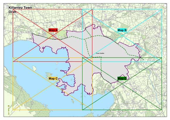
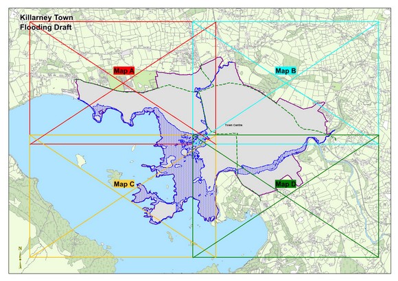
2.12 Land Use Zoning, Zoning Maps and Flood Maps
Closed6 Dec, 2021, 00:01 - 23 Feb, 2022, 17:01
2.12 Land Use Zoning, Zoning Maps and Flood Maps
This plan uses the My-plan classification for categorising land zones and full details are contained in Volume 6. The map legend pertaining to all Killarney maps is below.
For further details regarding land use zonings, it is recommended to use the online Map browser system at https://tinyurl.com/kerrycdp
|
Land use Zoning Objectives It is an objective of the Council to: |
|
|
KA 83 |
Ensure that the following is adhered to with respect of the C6 Enterprise zoning north of the Killarney Bypass:- • Ensure that a Natura Impact Statement, incorporating a Lesser Horseshoe Bat survey and impact assessment is required to be undertaken by a suitably qualified individual, in support of any development proposal for the lands in question. Proposals which would either directly or indirectly result in the loss of functionally linked habitat of importance to the Killarney National Park McGillycuddy Reeks and Caragh River Catchment SAC will not be permitted. • Ensure that any proposal to develop these lands should include a: (I) Landscape and visual impact assessments, (II) Traffic Impact Assessment addressing any impacts on the existing N22/Killarney by-pass from the proposed development, (III) An Ecological Impact Assessment, and (IV) An assessment under Article 6 of the Habitats Directive. |
Zoning Maps
Flood Maps
Contents
Observations
Observations