Due to the amount of information, facts and statistics not disclosed in the County Development Plan,
...
Chapter 3: Core & Settlement Strategy
Closed18 May, 2022, 00:01 - 16 Jun, 2022, 17:01
|
Chapter/Section |
Chapter 3, Section 3.10.3 |
|
Amendment Ref. |
3.1 |
|
Add Text The reference to population growth as contained in table 3.7 is not a population limit but a population target. |
|
|
Chapter/Section |
Chapter 3, Section 3.4 |
|
Amendment Ref. |
3.2 |
|
Amend Text Mobility and Transport -To support increased use of sustainable modes of transport; the integration of spatial planning with transport planning; enhanced county and regional accessibility; the transition to a low carbon energy efficient transport system; and the development of a safer, more efficient, effective, and connected transport system within Kerry. The Council will maintain the strategic function, capacity and safety of the national roads network, and ensure that the existing extensive transport networks, which have been greatly enhanced over the last two decades, are maintained to a high level to ensure quality levels of service, safety, accessibility and connectivity to transport users. |
|
|
Chapter/Section |
Chapter 3, Section 3.4 |
|
Amendment Ref. |
3.3 |
|
Amend Text Add the following new principles to Section 3.4; Circular Economy - To transition to a Circular Economy which recognises that all resources are scarce, and aims to maintain the value of all products, materials and resources through reuse, renewal and repair, so that products are reused continually, to minimise the generation of waste. Gaeltacht - To preserve and promote the use of Irish as a living daily-use language and to facilitate and support the provision of housing for Gaeltacht communities within Gaeltacht Areas. |
|
|
Chapter/Section |
Chapter 3, Section 3.5 |
|
Amendment Ref. |
3.4 |
|
Amend Map To include a new Core Strategy Map 3.1. |
|
|
Chapter/Section |
Chapter 3, Section 3.5.1.3 |
|
Amendment Ref. |
3.5 |
|
Amend Text There is significant potential for innovative projects, collaboration between stakeholders and sectors, infrastructure projects (including multi-modal transport infrastructure, more frequent public transport services and digital connectivity) to/ from and within the network to unlock the strengths and opportunities. |
|
|
Chapter/Section |
Chapter 3, Section 3.5.1.4 |
|
Amendment Ref. |
3.6 |
|
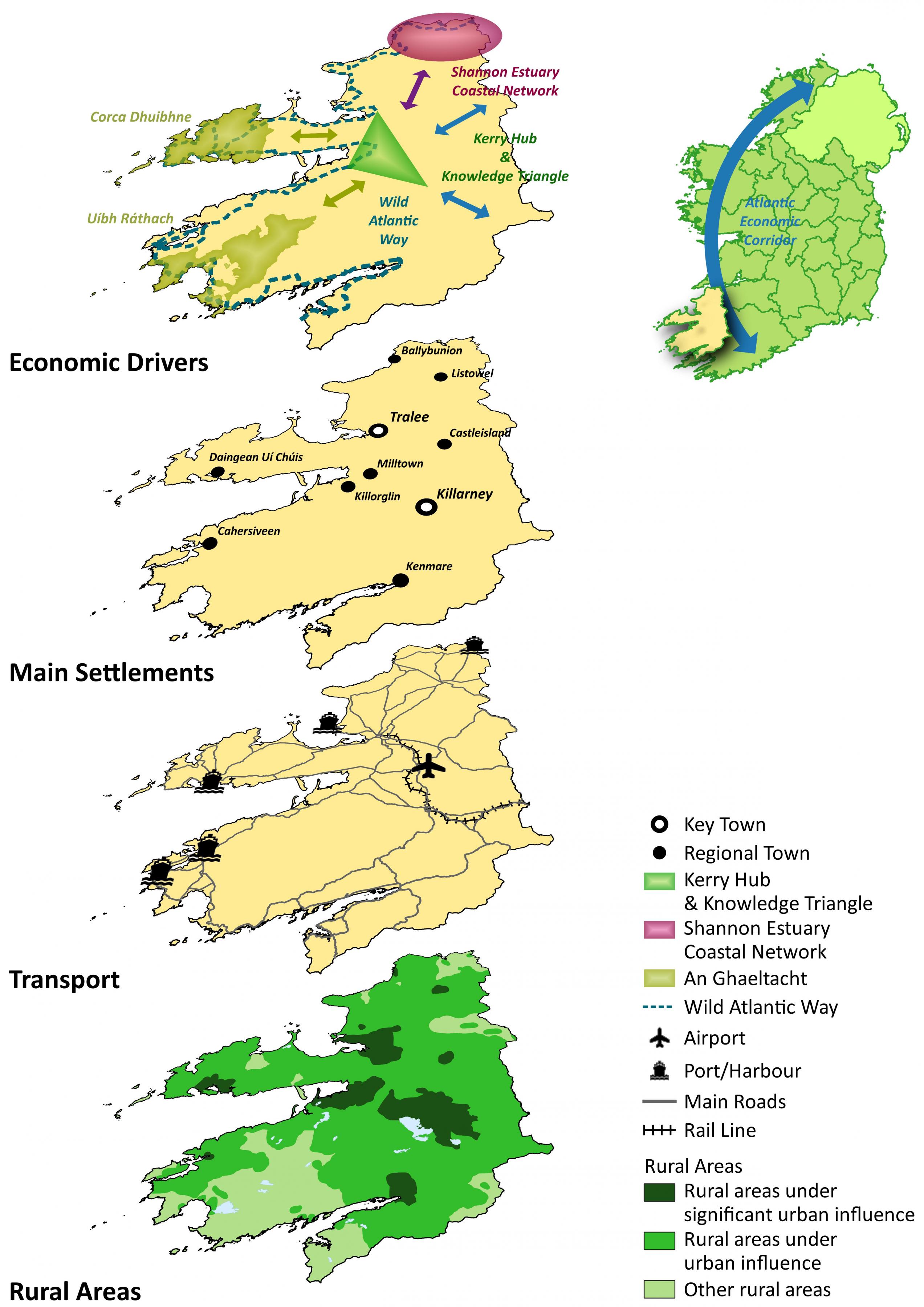
Amend Text Kerry County Council supports the economic role and potential of the established towns of Listowel, Abbeyfeale, Newcastle West (Key Town) and Kilrush as economic drivers in a potential North Kerry/West Limerick/Clare network connected with the Shannon Estuary referred to as the North Kerry/Shannon Estuary Network. This includes the Shannon Integrated Framework Plan (SIFP) area and strategic locations identified under the SIFP as a Shannon Estuary Coastal Network. This area is viewed as a driver for economic growth within the County and Region. There is potential for innovative projects, collaboration between stakeholders and sectors, infrastructure projects (including multi-modal transport infrastructure, more frequent public transport services and digital connectivity) to/ from and within the network to unlock the strengths and opportunities. This includes the County’s Regional Town of Listowel, Ballybunion and support for economic interaction with the AEC, Strategic Development Sites in the Shannon Estuary, the Kerry Hub and Knowledge Triangle and cross county boundary connectivity to other settlements in a network (including Newcastle West in Limerick as a Key Town, Port of Shannon Foynes, Limerick-Shannon Metropolitan Area etc). |
|
|
Chapter/Section |
Chapter 3, Section 3.5.1.5 |
|
Amendment Ref. |
3.7 |
|
Amend Text The airport lies within the Kerry Hub and Knowledge Triangle and therefore there exists opportunities for collaboration between stakeholders and sectors in order to further build upon the economic and infrastructural assets of the county. |
|
|
Chapter/Section |
Chapter 3, Section 3.10 |
|
Amendment Ref. |
3.8 |
|
Amend Table Amend Settlement Types Table 3.5 Key Town; Large population scale urban centre functioning as self-sustaining regional drivers, and strategically located urban centres with accessibility and significant influence in a regional and sub-regional context. Regional Town; Towns which provide a housing, employment, or service function serving a local region within the county. The category is broad and ranges from large commuter towns to more peripheral towns. |
|
|
Chapter/Section |
Chapter 3, Section 3.10.3 |
|
Amendment Ref. |
3.9 |
|
Amend Table Insert additional columns to the Core Strategy Table 3.7 |
|
|
Settlement |
Population |
Housing |
Land Zoning Required |
||||
|
Population 2016 (CSO) |
Population 2022 (est.) |
2022-2028 Pop. Growth |
Housing Target |
Existing Zoned Land (ha) |
Zoned Land Required (ha) |
||
|
County |
|
147,707 |
156,902 |
9,363 |
7,000 |
|
|
|
Key Town |
Tralee |
23,691 |
25,297 |
2,663 |
2,087 |
85.1 |
85.0 |
|
Killarney |
14,504 |
15,487 |
1,630 |
1,277 |
67.3 |
67.3 |
|
|
|
38,195 |
40,784 |
4,293 |
3,364 |
|
|
|
|
Regional Town |
Listowel |
4,820 |
5,127 |
529 |
415 |
10.8 |
10.8 |
|
Castleisland |
2,486 |
2,644 |
359 |
281 |
9.2 |
See new Settlement Capacity Audit Objective |
|
|
Kenmare |
2,376 |
2,527 |
261 |
204 |
29.9* |
||
|
Killorglin |
2,199 |
2,339 |
320 |
251 |
20.6* |
||
|
Dingle/ Daingean Uí Chúis |
2,050 |
2,181 |
282 |
221 |
17.5 |
||
|
Ballybunion |
1,413 |
1,503 |
204 |
160 |
7.1 |
||
|
Cahersiveen |
1,041 |
1,107 |
129 |
101 |
4.7 |
||
|
Milltown |
928 |
987 |
273 |
214 |
6.1 |
||
|
|
17,313 |
18,417 |
2,357 |
1,847 |
|
|
|
|
District Town |
Ardfert |
749 |
797 |
78 |
61 |
6.5 |
See new Settlement Capacity Audit Objective |
|
Ballyheigue |
724 |
770 |
77 |
60 |
2.6 |
||
|
Ballylongford |
391 |
416 |
45 |
35 |
1.1 |
||
|
Barraduff |
170 |
308 |
57 |
45 |
2.4 |
||
|
Castlemaine |
176 |
187 |
37 |
29 |
3.3 |
||
|
Farranfore |
175 |
186 |
42 |
33 |
7.1 |
||
|
Fenit |
538 |
572 |
130 |
102 |
6.6 |
||
|
Fieries |
558 |
594 |
46 |
36 |
1.5 |
||
|
Kilcummin |
435 |
463 |
40 |
31 |
2.2 |
||
|
Rathmore |
790 |
840 |
73 |
57 |
4.2 |
||
|
Sneem |
288 |
306 |
27 |
21 |
0.0 |
||
|
Tarbert |
540 |
574 |
57 |
45 |
3.1 |
||
|
Waterville |
462 |
491 |
52 |
41 |
3.1 |
||
|
|
6,924 |
7,492 |
760 |
596 |
|
|
|
|
Villages |
6,698 |
7,125 |
552 |
432 |
|
|
|
|
Small Village Settlements |
1,547 |
1,646 |
465 |
186 |
|
|
|
|
Rural Area |
77,958 |
82,425 |
936 |
575 |
|
|
|
|
* Existing zoning in Kenmare is that which is included in the Kenmare Functional Area Local Area Plan 2010-2016 and existing zoning in Killorglin is that which is included in the Killorglin Functional Area Local Area Plan 2010-2016, both prepared prior to the adoption of a Core Strategy. |
|||||||
Table 3.7: Population & Housing Growth 2022-2028
|
Chapter/Section |
Chapter 3, Section 3.10.3 |
|
Amendment Ref. |
3.10 |
|
Amend Text The allocation of population/housing has generally followed the scale of proportionality of existing settlement scale. Some District towns have been allocated increased levels of growth relative to other towns in that category. This has been done to ensure a balance between social and private development in these settlements due to Kerry County Council’s housing programme. There are also some capacity issues in relation to wastewater infrastructure and these settlements have been allocated a housing target that reflects this capacity. |
|
|
Chapter/Section |
Chapter 3, Section 3.11 |
|
Amendment Ref. |
3.11 |
|
Amend Text This Plan does not set out a quantum of lands to be zoned residential in order to meet the proposed population growth. The zoning of residential land will occur as part of the relevant settlement Local Area Plan (LAP) taking into consideration the level of housing demand indicated in the core strategy (see also Section 3.10), and a Settlement Capacity Audit of these settlements.
Zoning Maps for Tralee, Killarney & Listowel are included in Volume 2 of the Draft Kerry County Development Plan 2022-2028. As per Table 3.7, the Zoned Land Required, has been determined based on the Settlement Capacity Audit contained in Volume 2 for these settlements. It is proposed to phase residential lands in Tralee and Killarney in order to meet the housing targets of these settlements allowing for the contribution of brownfield/infill sites and to reflect the tiered approach to zoning. |
|
|
Chapter/Section |
Chapter 3, Objective List Heading Residential Zoning |
|
Amendment Ref. |
3.12 |
|
New Objective Prepare a Settlement Capacity Audit for each Regional Town and District Town where lands are zoned residential in their respective Local Area Plan which shall inform the zoned land requirements for these settlements. |
|
Contents
References
Observations
Observations
Ref Chapter3 Section 3.11
Zoning Maps for Tralee, Killarney & Listowel are included in Volume 2 of the Draft Kerry County Development Plan 2022-2028. As per Table 3.7, the Zoned Land...
Please see attached report for observations from the Southern Regional Assembly
Dear County Manager,
1. I object to the intention in the Amendments report to the County development plan, to exclude the Listowel Municipal District from the Kerry Hub and Knowledge Triangle...
Submission on the Amendments to the Draft Kerry County Development plan, 2022 to 2028.
Dear County Manager,
1. ...